
Canton Capobianco Area 20.45 km² | Local time Tuesday 6:09 PM | |
 | ||
Weather 13°C, Wind W at 31 km/h, 53% Humidity Points of interest Cap Corse, Giraglia, Moulin Mattei, Phare de la Giraglia | ||
Ersa is a commune of the Haute-Corse department of France on the island of Corsica.
Contents
Map of Ersa, France
Geography
Ersa is the northernmost commune of Corsica. It extends from Centuri to the West, to Rogliano to the East. Ersa is covered with shrubs and arid summits. The coast, which is carved to the West by the Cape Grossu (Cape Grosso) and the Punta of Corno of Becco, has beautiful beaches of sand and pebbles. The commune is watered by the streams Acqua Tignose and Granaghjulu on its undulating slopes of the Mount Maghjore (364 m).
History
The ancient Latin name of Ersa is Arsia. Human occupation predated Roman conquest.
The commune experienced Turkish occupation during 1555 to 1571. In 1592 the Republic of Genoa annexed Ersa, which allied itself to Pasquale Paoli in 1757.
Until the 17th century, the Cape Corse was the target of frequent incursions of barbaric pirates. When Corse joined France at the end of the 17th century there were 1130 inhabitants, highly involved in the cultivation of grapes for wine. Since then the population has dropped to about 135 inhabitants.
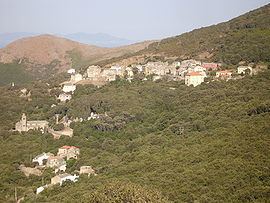
Villages
The villages of the commune of Ersa lie between the two summits. They are connected by the departmental route D80.
The ancient small port of Barcaghju, situated at the rear of the bay, near to the mouth of river Acqua Tignose, offers a panorama of the island of Giraglia. It occupies the location of a pre-Roman village. One finds here the chapel of Saint Peter and 2 km (1.2 mi) to the south the wrecked chapel Saint-Lucie. Its grand beach of fine sand presents a spectacular sand-dune. Near the commune of Rogliano, is the Genoese tower of Agnello, framing on the headland of Cape Agnello.
The second sea-front, Tollare, at the mouth of the River Granaghjulu, extends its ancient mansions around that of its chapel Saint-Anne and its round Genoese tower.
Environment
The old garbage dump has been removed. A new garbage recycling site has been created since 1 January 2009.
20 wind turbines (aerogenerators) have been erected (13 on Ersa and 7 on the neighbouring Rogliano). Inquiries of the French justice were undertaken because money was stolen for private and political purpose.