
Location North Pacific Total islands 14 Population 0 Elevation 3 m Island group Ratak Chain | Archipelago Ratak Highest elevation 3 m (10 ft) Area 153 ha | |
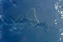 | ||
Erikub Atoll (Marshallese: Ādkup, [æ̯ær̪ʲ(ɛ͡ɔ)ɡʷu͡ipʲ]) is an uninhabited coral atoll of fourteen islands in the Pacific Ocean, located in the Ratak Chain of the Marshall Islands. Its total land area is only 1.53 square kilometres (0.59 sq mi), but it encloses a lagoon with an area of 230 square kilometres (89 sq mi). It is located slightly south of Wotje.
Contents
Map of Erikub Atoll, Marshall Islands
History
First recorded sighting by Europeans of Erikub Atoll was on 29 June 1566 by the Spanish galleon San Jerónimo then commanded by pilot Lope Martín. It is however likely that it had already been sighted previously by the Spanish expedition of Ruy López de Villalobos in between December 1542 and January 1543. Pilot Lope Martín who had been pilot of the patache San Lucas on its voyage from New Spain to the Philippines the previous year, had in this occasion mutineed with a gang of twenty six sailors and soldiers and murdered the San Jerónimo's captain, Pero Sánchez Pericón. The conspirators, including Martín would be later marooned in the Namonuito Atoll.
Erikub Atoll was claimed by the Empire of Germany along with the rest of the Marshall Islands in 1884. After World War I, the island came under the South Pacific Mandate of the Empire of Japan. Following the end of World War II, Erikub came under the control of the United States as part of the Trust Territory of the Pacific Islands. The island has been part of the independent Republic of the Marshall Islands since 1986.
Ecology
Loj island, within the atoll, is a nesting site of the green turtle.