
 | ||
Namonuito Atoll, also called Namonweito, Weito, or Magur Islands, is the largest atoll of the Federated States of Micronesia and of the Caroline Islands with a total area of 2,267 square kilometres (875 square miles), unless one considers the still larger Chuuk (Truk) Lagoon as a type of atoll in an early stage of development. In Micronesia, only Kwajalein Atoll of the Marshall Islands is still larger.
Contents
Map of Namonuito Atoll, Federated States of Micronesia
Namonuito Atoll lies in the northwestern region (Oksoritod) of Chuuk State, the largest federal state of the Federated States of Micronesia, about 170 kilometres (110 miles) northwest of Chuuk Lagoon (measured from Pisaras Islet to the northern and western parts of the fringing reef of Chuuk Lagoon. It is roughly triangular in shape, with the base running 82 kilometres (51 miles) along its southern side. The southwest corner of the triangle is marked by Ulul islet, the main island (largest and most populated), also called Onoun. The other islets lie mostly on the northeast side, from Pisaras islet in the southeast corner to Magur (Makur) islet in the north corner. The 12 islets have an aggregate land area of only 4.5 square kilometres (1.7 square miles). The total population is 1.341 (census of 2000).
The reef rim of the atoll is submerged for the greater part and is marked by the lighter colour of the water over it. The depths on the reef range from 0.9 to 18.3 metres (2 feet 11.4 inches to 60 feet 0.5 inches). The reef appears to be in the process of formation and can be crossed at many places. The lagoon is not of uniform depth. Except for a 5.5 metres (18.0 feet) patch, located 22 kilometres (14 miles) west of Pisaras island, and a detached reef, with depths of 2.7 to 3.7 metres (8 feet 10 inches to 12 feet 2 inches), located about 10 kilometres (6.2 miles) of Pisaras, there appears to be a depth greater than 9 metres (30 feet) on the scattered lagoon coral heads.
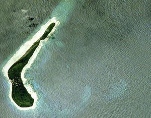
Pisaras Island has coconut palms and other trees growing on it. Reefs extend northwest and WNW from the island, enclosing a shallow and foul bay. Ulul Island is densely covered with coconut palms. A drying reef fringes the island. There is a radio station on the island.
The atoll is home to five of the 40 municipalities of Chuuk state, listed in counterclockwise sequence, with population (2000):
History
Namonuito was first visited by Spanish explores on the galleon San Jerónimo on 5 July 1566. At Pisaras Island, the rebel pilot Lope Martín and his gang of mutineers (thirteen soldiers and thirteen sailors) murdered Captain Pero Sánchez Pericón and other expedition members, and were subsequently marooned.
Onou Island was later visited by Spanish naval officer Juan Antonio de Ibargoitia commanding the vessel Filipino in 1801 who charted it as Anonima (Anonymous).