
Founded 1600 Area 294 km² | Department Lempira Climate Aw | |
 | ||
City since 3 March 1932; 85 years ago (1932-03-03) | ||
Erandique is a municipality in the Lempira Department of Honduras.
Contents
Map of Erandique, Honduras
Erandique is one of the several municipalities of the Lempira department. One has to travel 65 kilometres (40 mi) on road CA11A from the city of Gracias passing by San Juan (del Caite). A second road (V-787) that leads to Erandique is going by the town of "Dolores" in Intibuca. Also this roads leads to the municipality of San Francisco. The main disadvantage of this second road is that is not repaired often. If one enters from San Juan, Erandique has one exit to San Francisco and the other to the rest of the municipalities such as San Andrés and so on.
The town is served by Erandique (Gualguire) Airport, a grass airstrip 3 kilometres (1.9 mi) east of town.
History
Erandique was founded in 1600 under the name of "Cerquin", due to its location on the west of the Cerquin hill. It was registered in 1733 in the volume II of the Real State book, dated on 28 November. According to tales from elderly citizens, the original act was lost and it was replaced on 14 February 1882, in the administration of Dr Marco Aurelio Soto. Erandique is one of the oldest municipalities and it became a city on 3 March 1932.
Geography
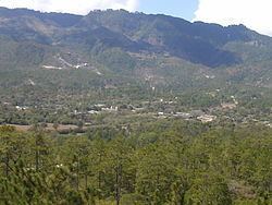
Erandique is still surrounded by pine forests, with some pockets of Sweetgum (Liquidamber) trees. The terrain is rugged, characterised by steep hills. The weather is cool during the rainy season (May–October), and warmer in the dry season. The predominant soil is derived from volcanic rocks. During the rainy season, this soil that forms from the degradation of the rocks becomes extremely slippery, and it is common for unpaved roads to wash away and for routes to become impassable. Many of the pine forests are still used as a source of biofuel for the local population.
Boundaries
Its boundaries are:
Population
Half of the population in Erandique are descended from native Indians. The other half of the population is mestizo (mixed-race ). During the holidays and other activities is when the direct descendants are seen; they still prefer to live isolated.
Tourism
The landscapes in Erandique are considered beautiful around the country due to the pine and swetgum (Liquidamber) forests.The people from Erandique are nice and welcoming. There are a couple of places for internet access. There are also several places to enjoy the typical food and only one that offers more variety of dishes, such as shrimps and seafood soup, since some come from the coastal city of La Ceiba. Downtown the visitor can see many old adobe houses. Some streets are paved with rocks and there are 2 very old churches to visit.