
OS grid reference TL435052 Post town EPPING Dialling code 01992 | Sovereign state United Kingdom Postcode district CM16 | |
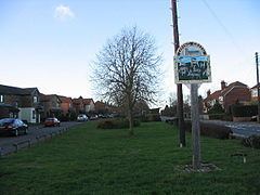 | ||
Epping Green is a village in the civil parish of Epping Upland and Epping Forest district of Essex, England, situated on the B181 road between Epping and Harlow.
Contents
Map of Epping Green, Epping, UK
The parish of Epping Upland, which stretches from the Wake Arms public house near Upshire at the south to the outskirts of Harlow at the north, takes in part of Thornwood Common at the east, and the hamlet of Rye Hill. Epping Green lies mainly within Epping Forest land although most farmland is owned by Copped Hall Estates and leased to the local farmers.
Through the village are ancient market routes and cattle drover's lanes, which were routes from as far afield as Norfolk. The traditional village pond was originally a blacksmith's cooling pond. The village has no shops but contains two public houses within 50 yards (46 m) of each other. The 13th-century parish church of All Saints' at Epping Upland, less than 1 mile (1.6 km) to the south-east, serves Epping Green, and was the original Epping church before St John's was built.
Between the 1920s and 1940s Epping Green consisted chiefly of wooden cottages built along a country road.
Bus
Epping Green has bus services to Epping and Harlow.