
Time zone CET (UTC+1) Area 30.15 km² Local time Saturday 6:29 AM | Region Occitanie INSEE/Postal code 12094 / 12140 Population 1,267 (1999) | |
 | ||
Weather 6°C, Wind E at 6 km/h, 61% Humidity | ||
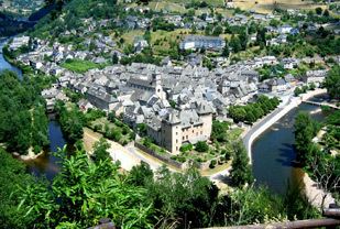
Entraygues-sur-Truyère (Occitan: Entraigas) is a commune in the Aveyron department in southern France.
Contents
Map of 12140 Entraygues-sur-Truy%C3%A8re, France
Geography
The village is located 600 km (370 mi) from Paris and 200 km (120 mi) from Toulouse.
Transportation
Entraygues-sur-Truyère can be reached by bus from Aurillac (48 km) and from the industrial center of Rodez (55 km). The nearest train station and airport are located in Aurillac or Rodez.
References
Entraygues-sur-Truyère Wikipedia(Text) CC BY-SA