
Existed: 1917 – present Length 950 m | East end: WYO 24 Area 3 miles (4.8 km) Constructed 1917 Added to NRHP 24 July 2000 | |
 | ||
West end: Devils Tower National Monument Entrance Location Devils Tower National Monument, Devils Tower, Wyoming | ||
New entrance road continues opening part 1
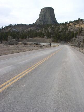
The Entrance Road at Devils Tower National Monument, officially known as Wyoming Highway 110, is a scenic road that provides the approach to the Devil's Tower eminence, affording planned views to arriving visitors.
Contents
- New entrance road continues opening part 1
- Inbound lanes of new entrance road prepare for opening
- Route description
- History
- Major intersections
- References
Inbound lanes of new entrance road prepare for opening
Route description
The Wyoming Highway 110 designation is a short 0.59-mile-long (950 m) roadway that starts its at Wyoming Highway 24 and travels west to the Devils Tower National Monument Entrance. Mileposts along WYO 110 increase from east to west.
The entrance road is a 3-mile (4.8 km) long, two-lane, asphalt paved road that spans the distance between the Entrance Station and the visitor parking area located just west of Devil's Tower. The road provides access to the monument's primary developed areas, such as headquarters and visitor center.
History
The road was originally constructed in 1917 with an eight percent grade and a ford at the Belle Fourche River. A bridge was built in 1928, and the road was extensively altered in the 1930s with labor from the Civilian Conservation Corps, improving grades and alignments. CCC camp NM-1 remained at Devil's Tower from 1935 to 1938. A complete loop was planned by the National Park Service Engineering Division in 1927, but was never carried out. The entrance road at Devils Tower is listed on the National Register of Historic Places as an example of close integration with the natural surroundings.
Much of the CCC work involved realignment of the existing road and the careful obliteration of the old alignment, using young trees and sod stockpiled during construction of the new alignment.
Major intersections
The entire route is in Crook County.