
Country United States GNIS feature ID 491643 Zip code 41037 Area code 606 | Time zone Eastern (EST) (UTC-5) Elevation 270 m Population 181 (2010) | |
 | ||
Area 2.663 km² (2.657 km² Land / 5,180 m² Water) | ||
Elizaville is a census-designated place and unincorporated community in Fleming County, Kentucky, United States. Its population was 181 as of the 2010 census. Elizaville is located at the junction of Kentucky Route 32 and Kentucky Route 170, 5 miles (8.0 km) west of Flemingsburg. Elizaville has a post office with ZIP code 41037.
Contents
Map of Elizaville, KY 41039, USA
History
A post office was established in Elizaville in 1819. The community has the name of a daughter of an early citizen.
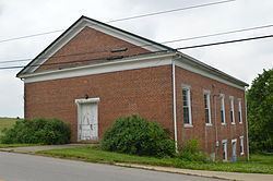
Historic sites in Elizaville include the Elizaville Presbyterian Church and Elizaville Cemetery.
References
Elizaville, Kentucky Wikipedia(Text) CC BY-SA