
References NVE Area 3.48 km² | Surface area 3.48 km (1.34 sq mi) Surface elevation 1,116 m Shore length 11.66 km | |
 | ||
Reference Norwegian Water Resources and Energy Directorate | ||
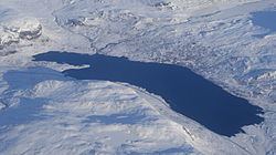
Eldrevatnet or Eldrevatn is a lake in the municipality of Lærdal in Sogn og Fjordane county, Norway. The 3.48-square-kilometre (1.34 sq mi) lake lies at an elevation of 1,116 metres (3,661 ft) above sea level. It is located about 15 kilometres (9.3 mi) southeast of the village of Borgund, not far from the European route E16 highway and the Filefjell Kongevegen road. The lake Øljusjøen lies 4 kilometres (2.5 mi) south of the lake. The lake Juklevatnet and the mountain Høgeloft both lie about 5 kilometres (3.1 mi) to the northeast of the lake.
Map of Eldrevatnet, 6888 Borgund, Norway
The lake Eldrevatnet is regulated by a hydroelectric dam and supplies water for a nearby power station.
References
Eldrevatnet Wikipedia(Text) CC BY-SA