
Prominence c. 70 m Elevation 470 m | Listing None OS grid SK115811 Mountain range White Peak | |
 | ||
Translation "Elves Hill" (Old English) Topo map OS Landranger 110, 119 OS Explorer OL1 Similar Rushup Edge, Crook Hill, Black Edge, Cheeks Hill, Harridge Pike | ||
Eldon Hill is situated in the Peak District National Park in the county of Derbyshire, England four kilometres southwest of the village of Castleton. It is a grass-covered limestone hill which reaches a height of 470 metres (1542 feet). It is primarily pastureland and is used for rough grazing, although a large proportion of the hill has been lost to limestone quarrying. It lies within the Castleton Site of Special Scientific Interest. Eldon Hill was formed when a bed of pure limestone was squeezed and upfolded by geological forces to form a dome; it is the highest limestone hill north of the River Wye.
Map of Eldon Hill, Buxton, UK
The hill is of considerable geological, historical and industrial interest; it lies at the northern limit of the carboniferous limestone in the Peak District, as further north it merges into the millstone grit of the Dark Peak. The name Elveden is first attested in 1285 as Elvedon and seems to have meant 'Elves' hill'.
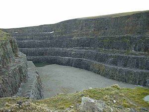
The main feature of Eldon Hill which strikes all visitors is the amount of quarrying that has been done on the site. Quarrying permission was granted in 1950 and huge quantities of limestone have been excavated, mostly for road-building purposes. A large amount of the northern and northwestern slopes of the hill have disappeared and it has been called the best-known eyesore in the Peak District. In 1995 an application by RMC Aggregates to extend the quarrying further east was denied as parliament tightened up on environmental problems caused by old mineral permissions granted between 1948 and 1981. The quarry closed in 1999 and now stands unused with vegetation starting to grow on the quarry face. There have been some attempts at natural restoration with several aquatic pools being established in the former workings. The termination of quarrying has also given cavers the chance to explore some of the narrow caves exposed by the work, with Sidetrack Cave being the most impressive.
350 metres south of the summit lies Eldon Hole. At 55 metres it is the deepest pothole in the area and was named as one of the Seven Wonders of the Peak by the philosopher Thomas Hobbes in 1636. According to folk tradition, it is the abode of the Devil. Close to the summit of the hill lies a Bronze Age tumulus, a large burial site measuring 16 by 15 metres and 1.5 metres high. The tumulus has been excavated on several occasions with human skeletons and jewellery amongst the finds. The hill is dotted with numerous lead mines all of which are disused with many of them capped off for safety.
Eldon Hill can be climbed either from the villages of Peak Forest to the south or Castleton to the north. The approach from Castleton goes up Cave Dale with a return down Winnats Pass to give a very interesting walk. The approach from Peak Forest is shorter and passes Eldon Hole on the way. The summit of the hill stands just 100 metres from the edge of the fenced quarry workings and gives good views with Mam Tor, Axe Edge Moor and the town of Buxton all well seen.