
Established 2004 | ||
 | ||
Website El Camino Real de los Tejas National Historic Trail Similar Mission Tejas State Park, George C Davis Site, Palo Alto Battlefield National, Presidio San Antonio d, Grulla National Wildlife R | ||
El camino real de los tejas national historic trail ribbon cutting part 2
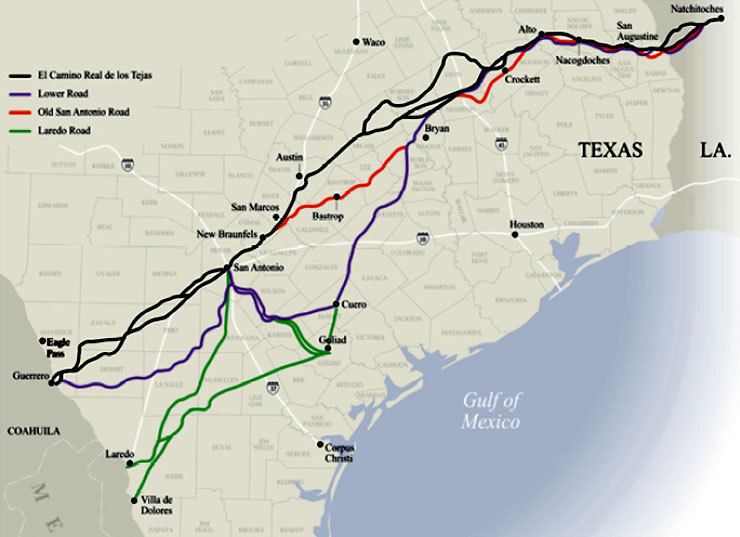
The El Camino Real de los Tejas National Historic Trail is a National Historic Trail covering the U.S. section of the El Camino Real de Los Tejas from 17th-century Spanish colonial era in Spanish Texas. The National Park Service designated the El Camino Real de los Tejas National Historic Trail as a unit in the National Historic Trail system in 2004.
Contents
- El camino real de los tejas national historic trail ribbon cutting part 2
- El camino real de los tejas national historic trail ribbon cutting part1
- History
- Preservation
- References
The modern highways Texas 21 (along with Texas OSR) and Louisiana 6 roughly follow the original route of the trail.

El camino real de los tejas national historic trail ribbon cutting part1
History
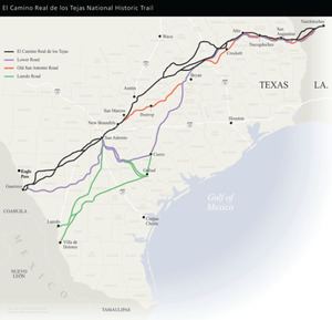
The historic trail ran from the capitol and central Viceroyalty of New Spain — present day Mexico City — winding through Saltillo, Monterrey, Laredo (on the modern Texas border), San Antonio, and Nacogdoches, before reaching the Louisiana border at the Sabine River. The river crossing was a ferry, in use since around 1795, as the Chabanan Ferry. James Taylor Gaines purchased the ferry in 1819, and it became known as the Gaines Ferry. Gaines sold the ferry in 1843 and at some point it began to be called Pendleton's Ferry. The ferry remained in service until being replaced by the Gaines-Pendleton Bridge in 1937.
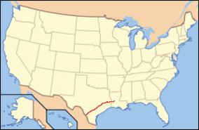
After crossing the river the trail went through the Neutral Strip and Many, Louisiana, before ending at Natchitoches in modern Louisiana. The trail has a 2,500-mile length. For centuries the Native Americans had used the trail routes for trading between the Great Plains and Chihuahuan Desert regions. The El Camino Real de Los Tejas was first followed and marked by Spanish explorers and missionaries in the 1700s. It was one of several named El Camino Real, or 'royal road,' that connected the Spanish possessions in North America with Mexico City.
Preservation
Interest in the road revived in the early twentieth century. In 1915 the Texas Legislature appropriated $5,000 to survey and mark the route, and professional surveyor V. N. Zivley was commissioned to make the study. A few years later Daughters of the American Revolution placed granite milestones along the route to mark it.
The National Park Service started planning for the El Camino Real de los Tejas National Historic Trail in 2006 with a Comprehensive Management Plan.