
Country Algeria Time zone CET (UTC+1) Population 14,752 (2008) | Elevation 458 m (1,503 ft) Area 750 km² | |
 | ||
Neighborhoods Martyr Razak Alzsigm | ||
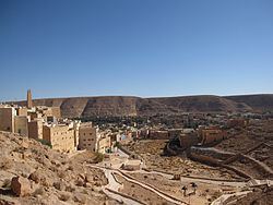
El Atteuf (Arabic: العطف) is a town and commune in Ghardaïa Province, Algeria. According to the 2008 census it has a population of 14,752, up from 12,713 in 1998, and an annual population growth rate of 1.5%. It is located in the M'zab valley about 6 kilometres (3.7 mi) east of Ghardaïa, the provincial capital.
Contents
Map of El Atteuf, Algeria
Geography
El Atteuf lies on the banks of the Wadi Mzab, an intermittent river in the M'zab valley, downstream of Ghardaïa. The area has been listed as a UNESCO World Heritage Site. El Atteuf is the oldest town in the area.
Education
7.0% of the population has a tertiary education (the equal second highest in the province after Metlili), and another 16.6% has competed secondary education. The overall literacy rate is 89.4% (the highest in the province), and is 95.3% among males (equal highest in the province) and 83.2% among females (highest in the province).
Localities
The commune of El Atteuf is composed of four localities: