
Time zone UTC-5 Climate Csb Population 4,497 (2010) | Elevation 3,007 m (9,865 ft) Area code(s) (+593) 6 Area 5.2 km² Local time Wednesday 12:26 AM | |
 | ||
Weather 7°C, Wind NE at 5 km/h, 100% Humidity | ||
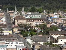
El Angel is a town located in the northern Andes of Ecuador, capital of the Espejo canton in the Carchi province.
Contents
Map of El Angel, Ecuador
Basic Information
History
Prehispanic settlements were confirmed due to the ceramic remains found in the sector of Las Tres Tolas. In 1851, El Angel became a parish of the Tulcan canton . From the twentieth century, new road infrastructure from El Ángel towards Tulcán and Ibarra cities, promoted the development of the town and the canton. The September 27, 1934 the Espejo canton was created, being its capital El Angel.
Economy
The main economic activities of the population are public, private services and trade, that are performed inside and outside the city; and secondary activities as agriculture, floriculture and livestock production.
Tourist Attractions
Access Routes
From the Pan-American Highway