
 | ||
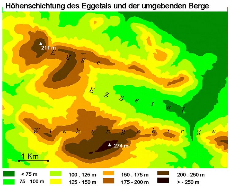
The Egge, also called the Preußisch Oldendorfer Berg is a roughly seven-kilometre-long secondary ridge of the Wiehen Hills and gives its name to the Eggetal valley in the districts of Osnabrück and Minden-Lübbecke in North Germany. The state border between North Rhine-Westphalia and Lower Saxony divides the ridge at a pass called the Durchbruch ("breakthrough") over which the road from Preußisch Oldendorf runs into the Eggetal and to Bruchmühlen, about two-thirds of the Egge belonging to Westphalia.
Map of Egge, 49152 Bad Essen, Germany
In addition to describing the entire ridge, in many maps the Egge is also shown as referring to a summit with a height of 198 m above sea level (NN) north of Eininghausen and eat of the Geisberg 201 m above NN; this usage is rare however. The section of the main crest of the Wiehen Hills between Neue Mühle and Horst Höhe is referred in maps as Die Egge ("The Egge").
The ridge runs parallel to the main crest of the Wiehen at a distance of around two to three kilometres from it and between the villages of Lintorf in the borough of Bad Essen and Bad Holzhausen in the borough of Preußisch Oldendorf.
The highest hill on the ridge is the 211-metre-high Schwarzer Brink in the west of the Egge. At the same time there is a parcel of arable land north of Büscherheide that, at 218 metres, is somewhat higher. The best-known hill on the Egge is the Limberg with its castle ruins of the same name that is situated in the far east of the ridge and is a popular tourist destination. Before it to the west is the Balkenkamp, a large, cleared upland over which runs a road link from the Landwehr to the B 65 federal road to Börninghausen.