
Population 220 (2011) Sovereign state United Kingdom | OS grid reference SK176429 Post town ASHBOURNE | |
 | ||
Edlaston top 5 facts
Edlaston is a village and civil parish three miles south of Ashbourne in Derbyshire, just off the A515 road. It includes the hamlet of Wyaston. The civil parish is called Edlaston and Wyaston. It had a population of 220 at the 2011 Census.
Contents
Map of Edlaston, Ashbourne, UK
Edlaston is mentioned in Domesday book as "Edolveston". It is very rural as the land is light and stony with a clay subsoil, which is suitable for dairy pasture. The village consists of a few farms and cottages and a traditional stone built public house The Shire Horse. To the west of the village is Edlaston Hall. It and its outbuildings have been converted to multiple dwellings.
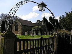
The church of St. James has a chancel, nave, south porch and a square wooden turret which has bells. The 14th century masonry is complemented by windows and a roof of a later date. The church was repaired in 1682 and 1840, and was restored and reseated in 1870.
Robert Kaye Greville, a notable botanist did many drawings here in Edlaston and Wyaston as a child as his father, Robert Greville, was the local rector.