
Population 31,609 (2001 Census) Civil parish Ecclesfield Dialling code 0114 | OS grid reference SK 352 940 Metropolitan borough Sheffield | |
 | ||
Region | ||
Ecclesfield is a village settlement and civil parish in the City of Sheffield in South Yorkshire, England, about 4 miles (6 km) north of Sheffield City Centre. Ecclesfield Civil Parish had a population of 32,063 at the 2011 Census. Ecclesfield wards of the City of Sheffield had a Population of 35,994 in 2011 (Ecclesfield West and Ecclesfield East wards).
Contents
- Map of Ecclesfield UK
- History
- Governance
- Amenities and setting
- Demography
- Landmarks
- Transport
- Sport
- References
Map of Ecclesfield, UK
History
Evidence of early settlement in the Ecclesfield area include remnants of Romano-British settlements and field systems in Greno Wood. The earliest known written record of Ecclesfield is from the Domesday Book of 1086, where it is referred to as "Eclesfeld". The meaning of the name is uncertain. Traditionally it has been interpreted to derive from the Celtic egles meaning a church (specifically a Romano-British church) and the Old English feld meaning a woodland clearing. Thus the name could mean 'Open land near a Romano-British Christian church’. However, alternative suggestions are that the first element eccles- derives from a Saxon personal name or an association with water.
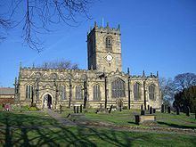
The Domesday Book does not mention a church at Ecclesfield. The present day Church of St Mary, largely dates from the late 15th century, but incorporates features dating from about 1200. It was the centre of the ancient parish of Ecclesfield, which was one of the most extensive parishes in England before it was broken up in the 19th century. The Benedictine Ecclesfield Priory was established in the 12th century and operated as a cell of St Wandrille's Abbey in Normandy until the 14th century. It is a Grade I listed building.
Ecclesfield had a paper mill in the 1800s.
Governance
Local issues in Ecclesfield civil parish are governed by Ecclesfield Parish Council. Parts of Ecclesfield were annexed by Sheffield City Council in 1968 and are now outside the civil parish boundaries and are under the sole control of Sheffield City Council. The civil parish includes all of the West Ecclesfield ward and most of the East Ecclesfield ward of Sheffield. These wards are part of the Penistone and Stocksbridge parliamentary constituency, which is represented in the House of Commons by MP Angela Smith of the Labour Party who has held the seat since 2005.
Amenities and setting
Ecclesfield has an old square, a cricket club, a large park, the Gatty Memorial Hall, a secondary school, Ecclesfield School, previously known as Ecclesfield Grammar, and a variety of shops and other civic amenities.
Ecclesfield is situated in the north of Sheffield, about 4 miles (7 km) north of Sheffield city centre. The suburb of Ecclesfield is in the south-eastern part of the civil parish with the suburbs of Chapeltown and High Green to the north, and Grenoside to the west. The elevation of the suburb ranges from about 60 metres (200 ft) to 120 metres (390 ft) above mean sea level. At the 2001 census the civil parish — which also includes the Sheffield suburbs of Chapeltown, Grenoside, High Green, and formerly Thorpe Hesley (now a suburb of Rotherham) — had a population of 31,609. Ecclesfield's old village is also home to Whitley Hall, a 16th-century mansion property converted into a four-star hotel and restaurant.
On the border of Ecclesfield is Greno Wood: a forested area listed as Grade B on the English Nature Invertebrate Site Register, as being of special archaeological and geological significance.
Demography
At the time of the United Kingdom 2001 Census the population of Ecclesfield civil parish was 31,609 people. The population of the suburb itself, which extends beyond the boundaries of the civil parish was about 7000 people The ethnic mix was 98.3% white (White British, White Irish, or White Other), 0.4% Asian, 0.4% Black British, 0.1% Chinese, and 0.8% mixed race. In 2011, Ecclesfield was 96.1% White British, 1.0% Asian, 0.4% White Irish, 0.5% Other White and 0.7% Black
Table outlining population change of the parish in 50 year increments since 1801:
Landmarks
The Church of St. Mary is a Grade I listed building, and the remains of Ecclesfield Priory and the Whitley Hall Hotel are Grade II* listed. Greno Wood is listed as Grade B on the English Nature Invertebrate Site Register, and is considered of special archaeological and geological significance.
Transport
The main road transport routes through Ecclesfield are the A61, which runs north-south through the parish, and the M1 motorway, which skirts the parish's eastern edge. Bus services provided by First South Yorkshire, Stagecoach Sheffield, Powells Bus Co., and TM Travel link the suburb with Sheffield City Centre, Barnsley, Rotherham, the Meadowhall Centre, and the surrounding suburbs. Chapeltown railway station, which is in the Chapeltown suburb, connects the parish with central Sheffield, Huddersfield and Leeds.
Sport
Ecclesfield F.C. were a prominent football team in the area from the 1880s, and Ecclesfield United also represented the area in the FA Cup. Ecclesfield Red Rose FC now represent the area and play in the Sheffield & Hallamshire County Senior Football League. Whitley Hall Cricket Club play at Cinder Lane in Ecclesfield.