
Type artificial lake Max. length 4 km (2.5 mi) Surface area 6.17 km (2.38 sq mi) Area 6.17 km² Length 4 km Width 2 km | Max. width 2 km (1.2 mi) Max. depth 43 m (141 ft) Surface elevation 243 m Volume 0.086 km³ | |
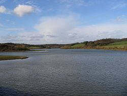 | ||
The Eau d'Heure lakes (French: lacs de l'Eau d'Heure) is a complex of five artificial lakes, forming the largest lake area in Belgium.
Map of Lac de l'Eau d'Heure, Belgium
The dams were built during the 1970s. The lakes are not far from the village of Cerfontaine, 50 kilometres (31 mi) south of the city of Charleroi, and the border with France. They are within the municipalities of Cerfontaine (province of Namur) and Froidchapelle (province of Hainaut).
The primary river feeding the lakes is the Eau d'Heure. There are five dams and one hydro-electric power station. The largest lake, the Lac de la Plate Taille, is itself the largest single lake in the country, at 3.74 square kilometres (1.44 sq mi), while together the lakes have a surface area of 6.17 square kilometres (2.38 sq mi).
It is a popular tourist attraction, with water sports, including fishing, kayaking, diving and windsurfing.
The five lakes are: