
OS grid reference NY247662 Sovereign state United Kingdom Local time Friday 2:54 PM | Dialling code 01461 | |
 | ||
Population 1,683 (2001 census)est. 1,790 (2006) Weather 9°C, Wind S at 14 km/h, 91% Humidity | ||
Gopro 4k annan eastriggs gretna solway estuary coast sw scotland
Eastriggs is a village in the south of Dumfries and Galloway. It has a small number of shops, a restaurant, post office, public house, working men's club and a church. Eastriggs Primary School feeds to Annan Academy.
Contents
- Gopro 4k annan eastriggs gretna solway estuary coast sw scotland
- Map of Eastriggs Annan UK
- The david buster robison goalkeeping experience cafe royal v eastriggs galabank 06 06 15
- Geography and administration
- History
- Church of St John the Evangelist
- References
Map of Eastriggs, Annan, UK
The david buster robison goalkeeping experience cafe royal v eastriggs galabank 06 06 15
Geography and administration
Eastriggs is built on generally flat land 10–20 metres above sea level. Annan is about 3 miles (5 kilometres) and Dornock 1 mi (1.6 km) to the west of Eastriggs, and Gretna is about 5 mi (8 km) to the east. They are each about 1–2 mi (2–3 km) north of the mud and sandbanks of the channel of the River Eden, which extends west into the Solway Firth.
Annan, Dornock, Eastriggs and Gretna are located on the B721, which runs parallel with, and is linked to the nearby A75. The Glasgow South Western Line connecting Carlisle, Gretna Green and Annan passes through the currently closed Eastriggs railway station. This station is disused, but there are plans to provide a smaller replacement one the line, which has been upgraded from single to double track, enabling simultaneous passenger and freight traffic.
History
Situated in the parish of Dornock, in the traditional county of Dumfriesshire, Eastriggs appears to have taken its name from the farm, or farm house, known as Eastriggs that was located in the middle of what was to become the new township. The only other buildings in the area prior to World War I were a group of houses at Lowtherton (now North Road, Lowthertown); a parallel group on what is now the B721 road; an inn and a smithy where East Road joins the B721.
The township of Eastriggs was created as a result of the shell and ammunition crisis of June 1915 which prompted the newly founded Ministry of Munitions to create a new cordite factory.
Officially designated H.M. Factory Gretna, the factory was spread over a 9-mile (14 km) site stretching from Dornock through Gretna to Longtown, Cumbria. This required a huge influx of labour, and 30,000 men and women came from all over the British Commonwealth to serve as construction and factory workers.
Sir Raymond Unwin, Chief Housing Architect of the housing branch of the Explosives Department of Ministry of Munitions, designed wooden housing for the workers in both Eastriggs and Gretna. As a mark of respect for the immigrant workforce, the streets were named after various cities within the Commonwealth.
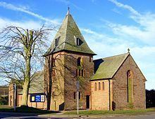
Church of St John the Evangelist
Designed in the Gothic style by C M Crickmer under the direction of Sir Raymond Unwin, the Church of St John the Evangelist was dedicated in 1917, and was presented with a signed altar book the following year by King George V and Queen Mary, who were paying an official visit to H.M. Factory, Gretna.