Official name E. J. Beardmore Dam Opening date 1972 Area 28.5 km² | Country Australia Status Operational Surface elevation 207 m Catchment area 71,560 km² Operator SunWater | |
 | ||
Inflow source Maranoa River, Balonne River | ||
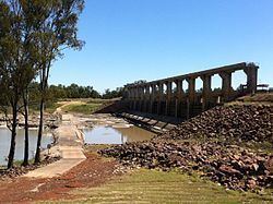
The E.J. Beardmore Dam, an earth-fill embankment dam with a concrete gravity wall across the Balonne River, is located in South West Queensland, Australia. The main purpose of the dam is for irrigation. The resultant reservoir is called Lake Kajarabie.
Location and features
Located 17 kilometres (11 mi) north-east of St George, the dam wall was constructed in 1972.
The dam wall is 15.2 metres (50 ft) high and 2,591 metres (8,501 ft) long and holds back 81,700 megalitres (18.0×10^9 imp gal; 21.6×10^9 US gal) of water when at full capacity. The surface area of the reservoir is 2,850 hectares (7,000 acres) and the catchment area is 71,560 square kilometres (27,630 sq mi). The uncontrolled spillway has a discharge capacity of 5,550 cubic metres per second (196,000 cu ft/s). Lake Kajarabie has an average depth of 2.4 metres (7 ft 10 in) and, when full, impounded water can back up some 75 kilometres (47 mi) along the Balonne River and almost 20 kilometres (12 mi) along the Maranoa River.
