
Isolation 0.88 mi (1.42 km) Elevation 4,225 m | Easiest route hike Prominence 145 m | |
 | ||
Topo map USGS 7.5' topographic mapMount Sherman, Colorado Similar Mount Buckskin, Horseshoe Mountain, Clinton Peak, Mount Sherman, West Buffalo Peak | ||
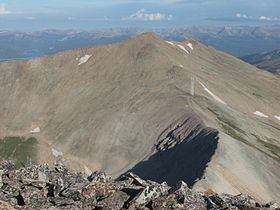
Dyer Mountain is a high mountain summit in the Mosquito Range of the Rocky Mountains of North America. The 13,862-foot (4,225 m) thirteener is located 5.9 miles (9.5 km) east (bearing 95°) of the City of Leadville, Colorado, United States, on the drainage divide separating San Isabel National Forest and Lake County from Pike National Forest and Park County. The mountain was named in honor of frontier preacher John Lewis Dyer.
Map of Dyer Mountain, Colorado 80461, USA
References
Dyer Mountain Wikipedia(Text) CC BY-SA