
OS grid reference TL481461 Local time Wednesday 11:06 AM | Sovereign state United Kingdom Dialling code 01223 Number of airports 1 | |
 | ||
Population 1,836 2,099 (2011 Census) Weather 12°C, Wind W at 16 km/h, 91% Humidity | ||
Duxford imperial war museum part1 largest aviation museum in britan
Duxford is a village in Cambridgeshire, England, about 10 miles (16 km) south of Cambridge. It is part of the Hundred Parishes area.
Contents
- Duxford imperial war museum part1 largest aviation museum in britan
- Map of Duxford Cambridge UK
- Boeing b 17 flying fortress sally b duxford uk 2016
- History
- Churches
- Airfield
- Village life
- References
Map of Duxford, Cambridge, UK
Boeing b 17 flying fortress sally b duxford uk 2016
History
The village formed on the banks of the River Cam, a little below its emergence from the hills of north Essex. One of the more populous settlements in its hundred it was split into two ecclesiastical parishes in medieval times until they were united in 1874.
Originally known as Duxworth and listed as Dukeswrthe in the 10th century, and Dochesuuorde in the Domesday Book the village's name comes from "Worth (enclosure) of a man called Duc".
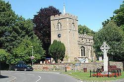
Churches
From medieval times the village was unusual in possessing two parish churches, each with a separate incumbent - these were St John's Church and St Peter's Church, only the latter of which still functions as a church. To the north of the village close to the Royston to Newmarket road lies Duxford Chapel, a 14th-century chantry chapel that was probably part of the Hospital of St John.
A Congregational chapel was built in the late 18th century and licensed in 1794, and at its peak in 1850 had a weekly congregation of 350. The chapel joined with other Congregational churches in uniting with the Presbyterian Church of England in 1972, and has been known as Duxford United Reformed Church since then.
Airfield
Duxford gives its name to RAF Duxford, a former Royal Air Force airfield that was used as a sector station during the Battle of Britain. Duxford Aerodrome was the home of Douglas Bader's Big Wing during that battle. Duxford airfield later became a fighter airfield for the United States Army Air Forces operating P47 Thunderbolt aircraft. In 1972 the Ministry of Defence began to house historically important aircraft in the hangars, which became the Imperial War Museum Duxford.
The airfield was used in the motion picture The Battle of Britain. During that production one of the hangars was blown up to simulate a Luftwaffe bombing raid.
Village life
The village has three remaining pubs – the John Barleycorn, the Plough and the Wheatsheaf. Former pubs include the Three Horseshoes, first recorded in 1786, and the King's Head which opened in the mid-19th century.