
Time zone WET (UTC+0) Elevation 43 m | Irish Grid Reference R815858 Local time Tuesday 4:13 AM | |
 | ||
Weather 4°C, Wind S at 14 km/h, 82% Humidity | ||
Dromineer (Irish: Drom Inbhir, meaning "ridge of the river mouth") is a small village and townland in County Tipperary, Ireland. It is situated on the shores of Lough Derg on the River Shannon. The village is located 10 km north of Nenagh on the R495 road. It is a civil parish in the historical barony of Ormond Lower. Historic documents describe the places as "Dromynnyre".
Contents
- Map of Dromineer Co Tipperary Ireland
- Features
- Buildings of note
- Dromineer Castle or Tower house
- Dromineer Church
- Recreation
- References
Map of Dromineer, Co. Tipperary, Ireland
Features
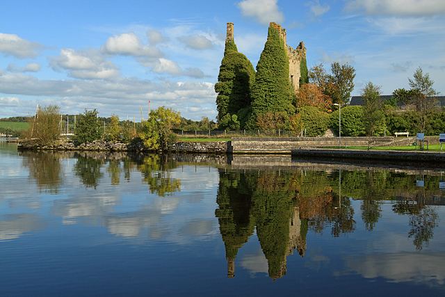
Home to an ivy-clad ruinous 13th-century Kennedy tower house, idyllic scenery, a public harbour and other facilities, it is a popular place to visit, especially for those boating on the lake. The name Dromineer in Irish is "Drom Inbhir", meaning the back or the ford of the river.
Amenities in Dromineer include a pub with restaurant, holiday accommodation, a café, a children's playground, public marina, private marina and boating clubs.
Dromineer is home to the Lough Derg Lifeboat, which is the RNLI's third inland lifeboat station and was the first inland station in the Republic of Ireland. During 2013 the Lough Derg Lifeboat launched 20 times and rescued 33 people.
Buildings of note
In addition to the O'Kennedy towerhouse (Ruined)
Structures listed as being protected by Tipperary County Council include Dromineer Quay and Canal store both date from around 1845 (RPS Refs S568 and S569)
Two corrugated iron roofed houses summer houses from the 1920s overlooking the lake. (RPS Refs S571 and S572)
Dromineer Castle or Tower house
Description and History – This is quite an unusual castle/towerhouse, in that its construction began as a 13th-century hall house, that was later converted into a tower house in the 15th/16th century. It was built by followers of Thomas Butler Esq. in the 13th century. The hall house was originally only two storeys high, but two additional storeys were later added, and vaults added to the ground floor. A base batter is present, and can be attributed to the earlier structure The conversion to a castle/towerhouse has resulted in an unusual rectangular shape to the castle which is 11×15 metres. By 1299, the Cantwell family were tenants, with Thomas Cantwell paying taxes on the castle. The building then fell into Gaelic hands, and the Ormond O’Kennedys were responsible for the remodelling of the building into a tower house. Many of the windows were modified during the conversion from hall to tower house.
In 1582 the Butler Earls of Ormond re-captured the castle/towerhouse, and the Cantwells returned as tenants until c. 1640.
In the Civil Survey of 1654–56 the castle was described as the "Mannor of Dromineer &c appertaineth a Courte Leete & Courte Barron with all the Rights privileges & immunities belonging to a mannor. Uppon the sd lands stands an old castle, six thatch houses, and fowerteene cottages." The proprietor of the castle in 1640 was John Cantwell, of Cantwells Court, in Kilkenny.
In 1650, the castle was seized by Cromwellian forces and garrisoned. It was returned the Earl of Ormond following the occupation by Cromwell. It was occupied until 1688. The castle/towerhouse fell into ruin in the late 17th century and was sold by the Earl of Ormond in the late 19th century.
A bawn wall also surrounds the castle in places. This is a lovely castle in a lovely location right on the shore of the lough. Many of the large quadrangular windows are 17th-century features.
Dromineer Church
The church is of considerable antiquity. It may have been built in 10th century. The tradition states that the monks from Holy Island built it.
It is located in the parish of Puckane & Carrig, which consists of a total of 71 townlands and is 18,310 statute acres or approximately 28.6 square miles in extent. The parish has a rich archaeological heritage, including a number of sites which have Early Christian religious associations, including Dromineer. Folklore also recalls four places in the parish where Mass was secretly celebrated during the Penal Days.
The parish was traditionally known as ‘Monsea’, ‘Monsea & Kilodiernan’ or ‘Monsea & Cloughprior’. These names reflect its origins because the present parish is an amalgamation of five medieval parishes, Cloughprior, Dromineer, Kilodiernan, Knigh and Monsea. The ruined churches at Dromineer was built in the Romanesque style, while those at Cloughprior, Knigh and Monsea were built in the Gothic style of the fifteenth century. The graveyards surrounding those churches are still used for burials and Mass is celebrated in each annually.
It employs exceptionally large blocks of stone.
It was extended in 12th century in the Celtic romanesque style.
The west doorway was still standing in the 1830s when John O'Donovan was here.
Carvings include dogs' heads with bulging eyes.
The church is located in the graveyard adjoining the public house.