
Country India Elevation 3,280 m | Time zone IST (UTC+5:30) Population 1,201 (2011) | |
 | ||
Weather -11°C, Wind SW at 5 km/h, 64% Humidity | ||
Keep the hills alive in dras kargil
Dras (Urdu, Burig: دراس ; Ladakhi: དྲས་ ; Hindi: द्रास) is a town in the Kargil District of Jammu and Kashmir, India on National Highway 1D (India) NH 1D. It is often called 'The Gateway to Ladakh'. The town shot into prominence in the summer of 1999 following Pakistani army incursions into Jammu and Kashmir. The Kargil War saw the town being shelled by the Pakistani army and the war ended with the Indian Army recapturing the areas surrounding the town and the Kargil district.
Contents
- Keep the hills alive in dras kargil
- Map of Dras 194102
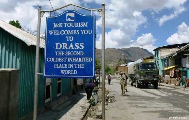
- Dras second coldest inhabited place in the world
- History
- Geography
- Trekking base
- Climate
- Demographics
- Places of interest
- References
Map of Dras 194102
Dras second coldest inhabited place in the world
History
Dras is a town in the Kargil District of Jammu and Kashmir, India. It is often called 'The Gateway to Ladakh'. It is at a height of 3230 m or 10990 ft. The mountain ridges however range from 16000 feet to 21000 feet.
The Dras valley starts from the base of the Zojila pass, the Himalayan gateway to Ladakh. For centuries, its inhabitants have been known to have negotiated this formidable pass even during the riskiest period (in late autumn or early spring, when the whole sector remains snow-bound and is subject to frequent snow storms) to transport trading merchandise and to help stranded travellers traverse the pass. They thereby established a monopoly over porterage during the heyday of the pan-Asian trade. A hardy people enduring with fortitude the harshness of the valley's winter, the inhabitants of Dras can well be described as the guardians of Ladakh's gateway.
Geography
Dras is located at 34.428152°N 75.75118°E / 34.428152; 75.75118. It has an average elevation of 3,280 metres (10,764 feet). It is 56 km from Kargil town on the road to Srinagar lying in the centre of the valley of the same name.
Trekking base
Dras also offers numerous shorter treks and hikes to the upland villages.
Climate
Dras is the coldest place in India, experiencing an altitude-influenced dry summer continental climate (Köppen climate classification Dsb). Winters are cold with average lows around −22 °C (−10 °F), and as low as −45 °C at the height of winter, which lasts from mid-October to mid-May. Summers start in June and go on up till early September, with average temperatures near 15 °C (60 °F) and little precipitation. Annual precipitation is almost entirely concentrated in the months from December to May when Dras gets around 550 millimetres (21.7 in) water equivalent of snowfall.
Demographics
Inhabitants of Dras, like many of the people of Gilgit, are Dard, Indo-Aryan people believed to have originally migrated to Ladakh from Central Asia. They speak Shina, a Dardic language. The small town has a Muslim majority and a few Buddhists. The local population is of 64% male and 36% female. In total the population of Dras is 1,201.
The Dras valley starts from the base of the Zojila pass, the Himalayan gateway to Ladakh.