
- elevation 4,400 m (14,436 ft) | - elevation 3,618 m (11,870 ft) | |
 | ||
- location Machoi Glacier near Zojila - location Suru River at Kharul Kargil - average 212 m/s (7,487 cu ft/s) | ||
The Dras River, also spelt Drass River (Urdu: دراس ندی), is a river in the Kargil district of Ladakh region, in the Indian state of Jammu and Kashmir.
Contents
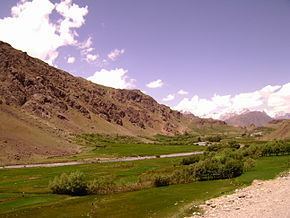
Map of Drass River
GeographyEdit
The Dras River is 86 km (53 mi) long and flows entirely in the Dras Valley. Its source lies in the Machoi Glacier near Zojila Pass, the gateway to Ladakh, 26 km (16 mi) east of Sonamarg and 120 km (75 mi) east of Srinagar, the capital of Jammu and Kashmir. The Machoi Glacier is also the source of the Sind River, which flows through the neighbouring Kashmir Valley in the opposite direction to the Dras River. The Dras River flows northeast, fed by many glacial streams. NH 1D, a national highway connecting Srinagar with Ladakh (Kargil and leh), runs parallel to the river. The river forms the Dras Valley at Dras, where it is joined by two tributaries, the Mashko Nala and Gamru Nala, which originate in the glaciers of Mashko Valley. In the Dras Valley, the road connecting Dras and Gurais runs parallel to the river.
The Shingo River joins the Dras River at Kharbu, and doubles the flow of the river. The Shingo River is a confluent of the Marpo River and the Nakpo River, both of which originate in Pakistani-Administered Kashmir. The Dras River joins the Suru River at Kharul, 7 km (4.3 mi) north of the town of Kargil. The Suru River is a left tributary of the Indus River. It originates from the Panzella glacier near Pensi La, flows northwards and merges with the Indus River at Nurla 5 km (3.1 mi) below its confluence with the Dras River, after entering Pakistani-Administered Kashmir at Post 43 and Post 44 of India and Pakistan respectively.
The Dras River flows through the towns of Matayan, Kharbu and Kakshar. The largest settlement on its banks is Dras, which is the second coldest inhabited place in the world after Siberia. The water flow of the river increases during the late summer, due to the heavy melting of glaciers.