
Existed: 1952 – present Length 11.9 km | Constructed 1952 | |
 | ||
South end: I‑75 / I‑85 towards Hartsfield-Jackson Atlanta International Airport North end: I‑75 / I‑85 in Midtown Atlanta | ||
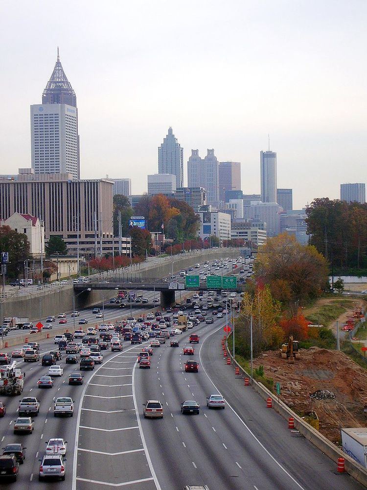
In Downtown Atlanta, the Downtown Connector or I-75/85 (pronounced "seventy-five eighty-five") is the concurrent section of Interstate 75 and Interstate 85 through the core of the city. Beginning at the I-85/Langford Parkway interchange, the Downtown Connector runs generally due north, meeting the west–east I-20 in the middle. Just north of this is the Grady Curve around Grady Memorial Hospital. Continuing north, the terminus of the Downtown Connector is the Brookwood Interchange or Brookwood Split in the Brookwood area of the city. The overall length of the Downtown Connector is approximately 7.5 miles (12 km). Since the 2000s, it has been officially named James Wendell George Parkway for most of its length, although it is still designated the Connector in the mainstream. It also has unsigned designations State Route 401 (I-75) and State Route 403 (I-85) along its length, due to I-75 and I-85 having a 400-series reference numbers.
Contents
Map of Downtown Connector, Atlanta, GA, USA
History
The Downtown Connector had its origins in the city's original system of expressways, construction of which began in the early 1950s with the Northeast Expressway and the South Expressway. Construction of the "connector" between the two, which was numbered State Route 295, and was slated to carry US 19/US 41 at one point, was not completed until the early 1960s.
Initial construction of the highway displaced parts of Techwood Drive and Williams Street in Midtown Atlanta. It also destroyed street grids east and south of downtown, dividing Sweet Auburn in two and the interchange with I-20 leveling the northern part of the Washington-Rawson district. The proposed I-485 was originally planned by the Georgia Department of Transportation to carry some south–north traffic through the eastern side of the city, but most of this was canceled in the 1970s by the then-governor of Georgia Jimmy Carter (Parts of that road are now I-675 and SR 400).
The highway was heavily reconstructed during the 1980s as part of GDOT's Freeing the Freeways program to widen Atlanta-area freeways, with most of the Connector's width being doubled from three to six or seven lanes in each direction. In addition to the general-purpose lanes, provisions for high-occupancy vehicle (HOV) lanes and dedicated on-ramps at Williams Street, Piedmont Avenue, and Memorial Drive were built, and were subsequently converted to HOV usage in 1996.
Between 2000 and 2004, the six-lane wide 17th Street Bridge was constructed over the Brookwood Interchange, connecting Midtown Atlanta with the then-new Atlantic Station development. In 2008, reconstruction of the 14th Street Bridge took place in order to accommodate increased traffic flow and pedestrian amenities. This work also included the construction of two new off-ramps: a southbound ramp to 10th Street, and a northbound ramp to 17th Street. This work was completed on May 28, 2010.
In early January 2010, a section of the highway between 14th and 17th streets developed an unusual problem dubbed "phantom ice" during a prolonged cold wave that kept temperatures below freezing for several days in the Atlanta region. GDOT engineers believe that heavy rain in previous months raised the water table and caused it to seep upward through joints between lanes, where it subsequently froze. Commuter traffic was stopped briefly on at least two days in order to treat it with deicing materials and inspect the freeway to determine the cause.
Features
The Downtown Connector carries more than 272,000 vehicles per day at its busiest point — between Martin Luther King Jr. Drive and Edgewood Avenue, while no portion of the Downtown Connector carries fewer than 236,000 vehicles per day. The area around the connector and associated interchanges are considered one of the ten-most congested stretches of interstate in the U.S. Due to this fact, many motorists often compare Atlanta to Los Angeles, which is also known for its notoriously-congested freeway system.
The highway is fully instrumented with Intelligent transportation system (ITS) devices. There are more than 25 closed-circuit television cameras between the Langford Parkway interchange (south end) and the Brookwood Interchange (north end). Additionally, the Downtown Connector has three large overhead electronic message signs, and four smaller HOV-dedicated message signs on the median barrier wall. Traffic flow data is gathered through a video detection system, using pole-mounted black-and-white cameras spaced every 1⁄3 mile (0.54 km) on both sides of the roadway. All video and data is fed into the GDOT's Transportation Management Center (TMC), via fiber optic cable located under the shoulders of the roadway. Virtually all entrance ramps are metered, with the exception of the freeway-to-freeway connection ramps from I-20.
Atlanta's skyline, both Downtown and Midtown, can be seen from the highway, especially at the northern and southern ends. The route also goes directly past Turner Field, formerly Centennial Olympic Stadium, where the opening and closing ceremonies and track and field events were held for the 1996 Summer Olympics.
Exit list
Exit numbers follow the mileposts along I-75.The entire route is in Atlanta, Fulton County.