
State California Incorporated December 23, 1908 Area code 530 Zip code 96023 Local time Friday 9:30 AM | Time zone Pacific (PST) (UTC-8) Elevation 1,294 m Population 907 (2013) | |
 | ||
Weather 11°C, Wind W at 8 km/h, 65% Humidity | ||
Dorris is a city in Siskiyou County, California, United States. The population was 939 at the 2010 census, up from 886 at the 2000 census.
Contents
- Map of Dorris CA 96023 USA
- Geography
- History
- 2010
- 2000
- Local attractions
- Infrastructure
- Education
- Government
- Notable people
- References
Map of Dorris, CA 96023, USA
Geography
Dorris is located at 41°57′54″N 121°55′8″W (41.965075, −121.918967). Dorris is located in the Butte Valley of Northern California between Mount Shasta and the Oregon Border on Hwy 97. According to the United States Census Bureau, the city has a total area of 0.7 square miles (1.8 km2), 97.81% of it land and 2.19% of it water.
History
The town was named in 1907 by the Southern Pacific Railroad for brothers Presley A. and Carlos J. Dorris who raised stock in Little Shasta in the 1860s before moving to Dorris' Bridge on the Pit River, renamed Alturas, California in 1876.
2010
The 2010 United States Census reported that Dorris had a population of 939. The population density was 1,307.5 people per square mile (504.8/km²). The racial makeup of Dorris was 764 (81.4%) White, 19 (2.0%) African American, 18 (1.9%) Native American, 5 (0.5%) Asian, 8 (0.9%) Pacific Islander, 77 (8.2%) from other races, and 48 (5.1%) from two or more races. Hispanic or Latino of any race were 197 persons (21.0%).
The Census reported that 939 people (100% of the population) lived in households, 0 (0%) lived in non-institutionalized group quarters, and 0 (0%) were institutionalized.
There were 364 households, out of which 125 (34.3%) had children under the age of 18 living in them, 171 (47.0%) were opposite-sex married couples living together, 47 (12.9%) had a female householder with no husband present, 23 (6.3%) had a male householder with no wife present. There were 33 (9.1%) unmarried opposite-sex partnerships, and 1 (0.3%) same-sex married couples or partnerships. 106 households (29.1%) were made up of individuals and 44 (12.1%) had someone living alone who was 65 years of age or older. The average household size was 2.58. There were 241 families (66.2% of all households); the average family size was 3.15.
The population was spread out with 240 people (25.6%) under the age of 18, 91 people (9.7%) aged 18 to 24, 216 people (23.0%) aged 25 to 44, 256 people (27.3%) aged 45 to 64, and 136 people (14.5%) who were 65 years of age or older. The median age was 38.2 years. For every 100 females there were 102.4 males. For every 100 females age 18 and over, there were 94.2 males.
There were 414 housing units at an average density of 576.5 per square mile (222.6/km²), of which 248 (68.1%) were owner-occupied, and 116 (31.9%) were occupied by renters. The homeowner vacancy rate was 3.9%; the rental vacancy rate was 7.2%. 584 people (62.2% of the population) lived in owner-occupied housing units and 355 people (37.8%) lived in rental housing units.
2000
As of the census of 2000, there were 886 people, 342 households, and 240 families residing in the city. The population density was 1,232.1 people per square mile (475.1/km²). There were 396 housing units at an average density of 550.7 per square mile (212.4/km²). The racial makeup of the city was 82.62% White, 5.53% Native American, 0.11% Asian, 0.11% Pacific Islander, 8.13% from other races, and 3.50% from two or more races. Hispanic or Latino of any race were 16.37% of the population.
There were 342 households out of which 32.7% had children under the age of 18 living with them, 52.0% were married couples living together, 14.9% had a female householder with no husband present, and 29.8% were non-families. 27.2% of all households were made up of individuals and 13.2% had someone living alone who was 65 years of age or older. The average household size was 2.59 and the average family size was 3.13.
In the city, the population was spread out with 30.6% under the age of 18, 7.6% from 18 to 24, 22.5% from 25 to 44, 23.6% from 45 to 64, and 15.8% who were 65 years of age or older. The median age was 35 years. For every 100 females there were 93.0 males. For every 100 females age 18 and over, there were 84.7 males.
The median income for a household in the city was $21,801, and the median income for a family was $24,265. Males had a median income of $25,139 versus $21,250 for females. The per capita income for the city was $11,447. About 17.9% of families and 19.1% of the population were below the poverty line, including 25.8% of those under age 18 and 3.5% of those age 65 or over.
Local attractions
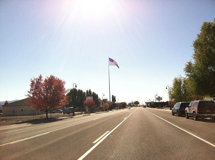
Notable locations in town include the Dorris Branch of the Siskiyou County Public Library, Dorris City Hall, Dorris Fire Department, three schools, the Siskiyou County Dorris-Tulelake Branch Courts and the Butte Valley Museum. Dorris is home to what was once the country's tallest flagpole west of the Mississippi. In 2002, a larger pole was erected in Laredo, Texas.
Infrastructure
U.S. Highway 97 is a major north–south United States highway and divides Dorris from southeast to northwest. California State Route 161 joins Highway 97 just north of Dorris.
The Butte Valley Airport (FAA LID: A32, formerly CA03) is a county-owned public-use airport located 5 miles (8.0 km) southwest of the central business district of Dorris.
The Butte Valley National Grassland is a 18,425-acre (7,456 ha) United States National Grassland located between Dorris and Macdoel along Highway 97.
Education
The Butte Valley Unified School District administers the elementary, middle and high school in Dorris.
The Butte Valley High School, (Bulldogs) are members of the Evergreen League, a high school sports league whose athletic teams are members of the Northern Section of the California Interscholastic Federation.
Government
In the state legislature Dorris is in the 1st Senate District, represented by Republican Ted Gaines, and the 1st Assembly District, represented by Republican Brian Dahle.
Federally, Dorris is in California's 1st congressional district, represented by Republican Doug LaMalfa.