
Area 66.52 km² | Population ca. 4,500 Local time Thursday 12:00 PM | |
 | ||
Weather 11°C, Wind W at 21 km/h, 95% Humidity | ||
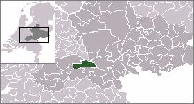
Dodewaard (51°55′N 5°39′E) is a town in the Dutch province of Gelderland. It is a part of the municipality of Neder-Betuwe, and lies about 7 km south of Wageningen.
Map of Dodewaard, Netherlands
Dodewaard was a separate municipality until 2002, when it became a part of Kesteren. Before 1818, the municipality was called "Hien en Dodewaard".
In 2001, the town of Dodewaard had 3090 inhabitants. The built-up area of the town was 1.1 km², and contained 1166 residences. The statistical area "Dodewaard", which also can include the peripheral parts of the village, as well as the surrounding countryside, has a population of around 4330. It also houses the now defunct Dodewaard Nuclear Power Plant.
References
Dodewaard Wikipedia(Text) CC BY-SA