
Location Ukraine Primary inflows Max. length 63 km (39 mi) Length 63 km Inflow source Dnieper, Southern Bug | Type estuary Basin countries Ukraine Max. width 17 km (11 mi) Width 17 km Cities Mykolaiv, Ochakiv | |
 | ||
2012 dnieper bug estuary mp4
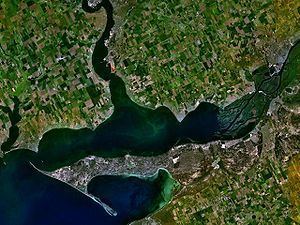
The Dnieper-Bug Estuary (Ukrainian: Дніпровсько-Бузький лиман) is an open estuary, or liman, of two rivers: the Dnieper and the Southern Bug (also called the Boh River). It is located on the northern coast of the Black Sea and is separated from it by Kinburn Spit and the Cape of Ochakiv.
Contents
Description
The estuary includes two parts: the wide Dnieper Estuary (55 km long, up to 17 km wide), and the narrower Bug Estuary (47 km long, from 5 to 11 km wide). The average depth is 6–7 metres (20–23 ft) and the maximum depth 22 metres (72 ft).
The estuary is important for transport, recreation, and fisheries. The most important port is Ochakiv.
Historical events
The estuary was a naval battleground in the Russo-Turkish War of 1787–1792. The Siege of Ochakov was a key event in that war, and naval battles – which involved the Russian Dnieper Flotilla, John Paul Jones's deep-water fleet, and the Ottoman Navy – included the First Battle of the Liman on June 7, 1788, and the Second Battle of the Liman on June 16 and 17.
Key landmarks
The ruins of Pontic Olvia are located on the right bank of the Southern Bug (Boh River), right at its mouth.
There is an artificial island which is often mistaken for Berezan Island, but it is actually Pervomaisky Island.