
OS grid reference ST818694 Dialling code 01225 | Sovereign state United Kingdom Postcode district SN13 | |
 | ||
Ditteridge is a hamlet in the civil parish of Box, Wiltshire, England. It is about 0.8 miles (1.3 km) northwest of Box and 3.5 miles (6 km) west of the town of Corsham.
Contents
Map of Ditteridge, Corsham, UK
Consisting today of a farm and a handful of houses, the ancient parish of Ditteridge (which included the hamlet of Alcombe) had a larger population, peaking at 119 at the 1851 census. The civil parish, created in 1837, was combined with Box in 1884.
The Fosse Way Roman road passes 1.5 miles (2.4 km) west of Ditteridge. The settlement was recorded as Digeric in the Domesday Book of 1086. Cheney Court is from the 17th century and is Grade II* listed.
From circa 1849 a school was associated with the church; after it closed in the 1880s, children attended the school at Box.
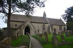
Parish church
The church of Saint Christopher retains Norman features. It dates from circa 1100 and has a 13th-century chancel and a 14th-century south porch. Restoration by E.W. Godwin in 1860 included a pulpit and stained glass. The church was designated as Grade I listed in 1960.