
Founded by Adinabegh Local time Wednesday 2:51 AM | Established 1730 Demonym(s) Dinanagari | |
 | ||
Weather 14°C, Wind NE at 10 km/h, 66% Humidity University S.S.Institute of Management & Technology Neighborhoods Berian Mohalla, Harijan Colony, Golden Avenue Colony, Arya Nagar, Chander Vihar Points of interest Maharaja Ranjit Singh's C, MUGRALI GATE, AWANKHI GATE | ||
Dina Nagar is the 3rd largest town and a municipal council in Gurdaspur district in the state of Punjab, India. It takes its name after Adina Beg, one of Akbar's loyalists to whom the emperor granted Jagirs (big land holdings) in this area.The town came up during Akbar's regime and old buildings, bazaars and the walled portion of the town and its gates are a witness to all this.
Contents
- Map of Dinanagar Punjab 143531
- History
- 2015 attack
- Location
- Topography
- Climate
- Rainfall
- Ecology
- Hydrology
- Soils
- Minerals
- Demographics
- Rail
- Road
- Colleges in Dinanagar
- CBSE School
- PSEB Schools
- ICSE School
- References
Map of Dinanagar, Punjab 143531
History
Dina Nagar town is situated about 14 l, North-East of Gurdaspur. It was founded by Adina Beg in 1730, on the bank of Hasli or Shah Nahar as his residence and cantonment. He seems to have exercised his government from this town.
Dina Nagar was a favourite summer resort of Maharaja Ranjit Singh. It was one centre where Singh usually held his Durbar during the summer. It was Singh's summer capital. He spent the two months of May and June every year at Dina Nagar. It was here that in May 1838 he received the Macnaghten mission which negotiated the proposed alliance for placing Shah Shujah Durrani on the throne of Kabul.
After the annexation of the Punjab as British territory in March 1849, a new district of Adinanagar was constituted with Dina Nagar as its headquarters. Gurdaspur Tehsil, a greater portion of Batala Tehsil and 181 villages of Pathankot Tehsil were included in the Adinanagar district. In July 1849 the civil and Military escorts were transferred to Batala as Dina Nagar was thought unhealthy and in 1852 it became part of Gurdaspur district. The Rowlatt ACT passed in March 1919 invested the Government with extraordinary powers to suppress any kind of political agitation. A complete hartal was observed in Dina Nagar along with Gurdaspur, Pathankot and Batala.
In 1920 the non-cooperation movement was started by Mahatma Gandhi due to alliance with Khilafat leader Jallianwala Bagh massacre and Rowllat Act. The people all over the country responded to the call of Gandhi. The Government made every effort to stop the movement and a large number of persons courted imprisonment. A durbar was held at Dina Nagar to discuss the situation created by Gandhi by H. Harcourt, the Deputy Commissioner.
Swami Sawtantra Nand founded Dayanand Math in 1938 – an institution which became a centre of learning and Ayurveda. In the course of time Adinanagar has been known for its Loi, Shawl and wood industries. A number of conduit pipe manufacturing units have been set up here after 1947. Dina Nagar is spread over 14.36 km2.
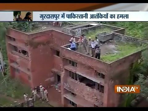
2015 attack
The 2015 Gurdaspur attack on the police station in Dina Nagar resulted in 10 deaths (including the 3 attackers), and 18 injured. Killed were two civilians, Superintendent of Police (Detective) Baljit Singh, two home guards and two policemen.
Location
Dina nagar is the northern-most town of Punjab state. It falls in the Jalandhar division and is sandwiched between the Ravi and Beas Rivers. The town shares common boundaries with Pathankot district in the north, Beas River in the north-east, Hoshiarpur districtt in the south-east, Kapurthala district in the south, Amritsar district in the south west and india in the north-west.
Topography
The land scape of the town has varied topography comprising undulating plan, the flood plains of the Ravi and the Beas and the up land plain. It is traversed by a number of chaos and has an undulating topography. The flood plains of the Ravi and the Beas are separated from the up land plain by sharp river cut bluffs. They are low lying, with slightly uneven topography. Sand dominates in the soil structure of the flood plains, but it diminishes in both quantity and coarseness in the upland plain. The up land plain covers a large part of the town particularly.
Climate
There are mainly two seasons i.e. summer and winter. The summer season falls between the months of April to July and the winter November to March. In summer season the temperature touches 44 °C or even sometimes crosses it. June is the hottest month and January is the coldest one. Mostly the rain falls in the month of July. The winter rains are experienced during January and February. Dust storms occurs in the month of May and June.
Rainfall
The south-west monsoon generally arrives in the first week of July and continue up to the end of August. 70% of the rainfall occurs during this period.
Ecology
The changes in ecology system are inevitable, consequences of development process. The denudation of forests due to increasing population, urbanization industrialization have accelerated the process of environmental degradation in the town. Therefore, preservation of the ecology is one of the most important goals of the town planning. The vegetation varies in the town depending on the soil, topography and elevation. In the Plain, large scale of afforestation has been under taken by the forest department. Where water facilities are available, Shisham, mulberry, eucalyptus and poplar are being planted. Besides mango and mulberry, other fruit trees cultivated in the town include orange, Kinnow Lemon tree etc.
Hydrology
The ground water in this region is suitable for irrigation and domestic uses. The sub soil water depth ranges from 5 to 8 meters in most part of the town. Due to 'Dhusi bandh'| and stepped floods the water table has gone very low.
Soils
The soils are loamy with a clay content below 10 percent. They contain small quantities of lime but the magnesia content is high. They are well supplied in potash and phosphoric acid but the quantities available are low. The agriculture is dependent to a large extent on the nature of its soils which in turn, is influenced materially by climatic factors. The cultivable waste land is fallow or covered with bushes or jungle which may not be put to any use. Lands under that ching grass bamboo, bushes, tree crops etc. which are not included under forests have been considered as cultivable waste. As for example, all growing lands which are permanent pastures, meadows, grazing lands within the forests etc.
Minerals
The foundry sand is found from Dharamkot near Batala. The deposits are located 6.5 km west of Batala. The sand gives a yellowish tinge on the surface but is reddish brown at about 1 meter depth. The salt occurs in the village Pandori near Dinanagar. It is a source of potassium nitrate which can be used for making crackers and gunpowder, in match and sugar industry and as fertilizer.
Demographics
As of 2001 India census, Dina Nagar had a population of 21,494. Males constitute 52% of the population and females 48%. Dina Nagar has an average literacy rate of 75%, higher than the national average of 59.5%: male literacy is 78% and, female literacy is 69%. In Dina Nagar, 11% of the population is under 6 years of age. This part of Gurdaspur district has better sex ratio as compared to some other parts of Punjab. It was basically made by Maharaja Ranjit Singh. There are six darwajas for city. And then the name of city on the of Adinabage, who was the last Mugal governor. The name was Adinanagar, then the name changed to Dinanagar. The maharaja rest house in Dinanagar became Agurudwara Shere Punjab.
Rail
Dinanagar's railway station is connected with the nearest station Pathankot and Amritsar. From Dinanagar there are many trains to Pathankot and Amritsar, and two main trains: Jammu Tawi (Jammu to Tata Nagar) and Pathankot-Delhi express.
Road
Dinanagar is well connected with road network: National Highway 15 (NH 15) is a major National Highway in Western and Northwestern India. NH 15 connects Kandla in Gujarat with Dinanagar in Punjab.