
Parent range Aravali Range Elevation 1,170 m | Easiest route Hike / scramble Range Aravalli Range | |
 | ||
Similar Madhogarh Fort - Haryana, Nahar Singh Mahal, Nahar Wildlife Sanctuary, St Thomas Church - Hisar, Crocodile Breeding Centre - K | ||
Dhosi hills
Dhosi Hill is an extinct volcano, standing alone in the North-West end of the Aravali mountain range with height varying from about 345 to 470 meters from the surrounding land and 1170 meters from the sea level; has temple, pond, fort and caves on the top and forest around it.
Contents
- Dhosi hills
- Map of Dhosi Ka Pahad Haryana 333746
- Dr ramesh dhosi hill
- Location
- Dhosi Hill Seasonal Waterfall
- Fort
- Parikrama
- Temples and religious melas
- References
Map of Dhosi Ka Pahad, Haryana 333746
The hill is unique, for the reasons, it has all the physical features of a perfect volcanic hill with distinct crater, lava still lying on it and giving a perfect conical view from top.
Dr ramesh dhosi hill
Location
Dhosi Hill is located on the borders of the Indian states of Haryana and Rajasthan. The Haryana portion lies in Mahendragarh district to the south, 5 kilometres (3.1 mi) from Narnaul on Singhana Road; the Rajasthan portion lies in Jhunjhunu district to the north.
While the ground level is about 900 feet (270 m) above sea level, the hill top is another 900 feet above the ground level.
Dhosi Hill Seasonal Waterfall
The hill presently falls under the administration of three village panchayats, being those of Dhosi in Jhunjhunu district of Rajasthan state and of Thana and Kultajpur in Mahendragarh district of Haryana state. These villages are situated on the three waterfalls that become active during the monsoons that occur in July–August, being created from the overflow of a reservoir at the summit. The waterfalls are mentioned in the epic Mahabharata. Each village also has an ancient water reservoir to augment the supply for villagers and animals.
Fort
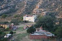
Dhosi Hill has remnants of a fort built by Hemu about 500 years ago. There are thick walls, up to 25 feet (7.6 m) high and 40 feet (12 m) wide on even the steepest slopes and the top of the volcano. The fort was constructed to safeguard the heritage and ashrams on the hill from frequent attacks by Muslim invaders during the medieval period. To replace the old temple, a fort modeled on the temple of Chyavana was built at the crater of the hill in the 1890s by the Bhargava community.
All-weather stairs in stone and lime plaster are constructed on the Kultajpur and Thana sides.
Parikrama
Those visiting the hill on pilgrimage have performed a parikrama (circumambulation) of it since the time of Shaunak. The 8–9 km parikrama track includes some portions of which are damaged because of landslides.
Temples and religious melas
Apart from temples at Shiv Kund, halfway to top of hill from Kultajpur side, there are several temples on the crater portion of the hill. Among these is the Chyavana temple, the Shiva temple on the crater, a Devi temple on the hilltop, and a Rama temple next to the Royal Guest House. The Chyavana temple has Shekhawati paintings in the Garbhagrah of the temple and a basement which can be used as a Dharmshala (resting place) for pilgrims. Among other structures on the hill is the renovated Chandrakoop.
Melas are organised on various festivals and other special days. On the day of Somvati Amavasya many people assemble for a holy bath in the sarovars. A map from the 1890s indicates there were then separate Ghats for women, known as Janana Ghats, but now they are abandoned.