
Total islands 8 Highest elevation 213 m (699 ft) Elevation 213 m | Adjacent bodies of water Solomon Sea Major islands PanaeatiPanapompom Highest point Mount Deboyne Area 39.14 km² | |
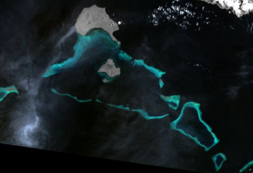 | ||
The Deboyne Islands are an atoll, composed of a group of reefs and islands in the north of the Louisiade Archipelago, Papua New Guinea.
Contents
Geography
They are located 13 km (8 mi) from Misima and 5 km (3 mi) from the Torlesse Islands. Islands in the Deboyne Islands include Panaeati (the northernmost), Panapompom, Nivani, Pana Uya Wana, Rara, Losai, Nibub and Passage Island.
History
The Deboyne Islands were discovered in 1793 by Antoine Bruni d'Entrecasteaux. he named the islands the archipelago and named it after Pierre Étienne Bourgeois de Boynes, which was the Marine and Colonial Minister of France at that time. During World War II, the islands were used as a seaplane outpost by the Imperial Japanese Navy, from 5–12 May 1942.
Population
The settlements in the main island Panaeati are all located on the south coast of the island, facing the lagoon. the language spoken on the islands is Misima-Paneati language.
Economy
Nivani, the small island south of Panapompom, has a small vocational school and slipway. Yachts are regular visitors to the Louisiade Archipelago. Nivani is a favorite anchorage for these yachts, with averages of about 15 yachts a year. A small ecotourist resort was recently built at Nivani that would respect the environment, yet provide business opportunities for the population of Panapompom community. The resort is a success especially with yachtsman, divers and film crews.