
Highest elevation 31 m (102 ft) Area 208 ha Major islands Tinolan; Pananiu | Highest point Mount Pananiu Elevation 31 m Total islands 2 inhabited | |
 | ||
LLG Louisiade Rural Local Level Government Area | ||
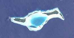
The Torlesse Islands are an archipelago in the Solomon Sea . Politically they belong to Milne Bay Province in the southeastern region of Papua New Guinea. They are 13 km away from Misima and 5 km west of Deboyne Islands. The aggregate land area of the seven islands is 2.08 km². The main village is Tinolan. it is inhabited by a family from Panaeati Island who grow Copra.
Map of Torlesse Islands, Papua New Guinea
References
Torlesse Islands Wikipedia(Text) CC BY-SA