
Average depth 47 feet (14 m) Max depth 61 m Mean depth 14 m | Primary inflows Area 55.85 km² Length 1.036 km Outflow location Caddo River | |
 | ||
Surface area 13,800 acres (5,600 ha) | ||
DeGray Lake is a reservoir on the Caddo River in Arkansas, 8 miles (13 km) from Arkadelphia. DeGray Lake offers a huge span of recreational area and spectacular views. Arkansas Scenic Byway 7 is located on the eastern shore of the lake, and provides views of the lake, and also places to stay down the road. DeGray Lake Resort State Park was opened in 1974 to encourage tourism and recreation on DeGray Lake.
Contents
Map of De Gray Lake, Arkansas, USA
Prehistory
The history of the DeGray area dates back to AD 700 when the area was inhabited by the Caddo Indians. Hernando de Soto then came and explored this area in 1541, after discovering hot springs. The Caddo Indians' way of life was changed forever when coming in contact with the Spanish explorers; the Indians were introduced to the horse. In the 18th century French fur trappers brought trade to the area with their extensive trapping methods. DeGray Lake was in fact named after a French fur trader, DeGraff, who settled this region. Several artifacts have been found near the dam site, and many have been brought to a local university, Henderson State University.
Dam construction
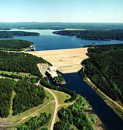
DeGray lake and dam were authorized by Congress in the River and Harbor Act of 1950. Congress passed the Water Supply Act of 1958, which provided for the inclusion of municipal and industrial water supply as one of the project purposes. Construction on the dam began in 1962 and was completed in 1972 at a cost of $63,800,000. A 40 MW hydraulic turbine and a 28 MW turbine generate electricity for the Southwestern Power Administration of Arkansas, Texas, and Oklahoma. DeGray dam impounds the waters of the Caddo River to form a flood control lake that covers 13,400 acres (5,400 ha), and a shoreline of 207 miles (333 km).
Many of the long-time residents recall families in the area who were "bought out" in order to fill area behind the dam. Residents were offered money for their property, so that the lake could be built. The eventual damming of the Caddo River forced many people to move elsewhere in the area. Brick and concrete structures from former homesteads still stand on the bottom of the lake.