
Country Iran District Central Highest elevation 695 m (2,280 ft) Local time Saturday 1:03 AM ISO 3166 code Ilam Province | County Darreh Shahr Elevation 660 m (2,170 ft) Area 3.05 km² Province Ilam Province | |
 | ||
Neighborhoods List
City Center
Kuye Taleghani
Kuye Motahari
Kuye Farhangian
Kuye Isargaran
Maskane Mehr
Arazi Shahri (Urban Territories)
Sorkh-abad
Chahar-zoghal Weather 12°C, Wind SW at 3 km/h, 85% Humidity | ||
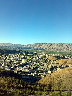
Darreh Shahr (Persian: دره شهر; also Romanized as Darreh-ye Shahr) is a town and the capital of Darreh Shahr County, Ilam Province, Iran. It's situated in a wide valley in the northern hillsides of Kabir Kuh ranges. At the 2011 census, its population was reported 24,961. The ruined ancient city of Darreh Shahr Ancient City is located in the southern part of Darreh Shahr. It has been extensively excavated by archaeologists. The Seymarah River flows to the north of the city. The city has a lot of potentials in agriculture, rich water supplies, green fields and dense forests.
Contents
- Map of Darreh Shahr Ilam Province Iran
- Ancient times
- Recent history
- Name appellation
- Geography
- Climate
- Flora
- Fauna
- Economy
- Carpentry
- Main Attractions
- Transportation
- Darreh Shahr Ilam route
- Kabir Kuh Tunnel
- Health care
- References
Map of Darreh Shahr, Ilam Province, Iran
In ancient times Darreh Shahr has been the summer capital of Elam dynasty and it thrived on Sassanid Empire era.
Ancient times
In ancient times, Elamites governed the Lorestan mountains and constructed several strong buildings. Darreh Shahr was the first Elamite city attacked and destroyed by Assyrians in addition to the massacre of people. In Seymareh Valley the remains of the Sassanid monuments are still present; hence Darreh Shahr might have been a thriving city in the Sassanid and the Parthian periods. Furthermore, some foreign experts call the unearthed city as the second and lost capital of the Seleucids while some Iranian archaeologists believe that the monuments are part of the state of Sirvan. Referencing some resources and texts, Darreh Shahr may be the same as Mehr Jaan Ghazagh, Saabzaan, Seymareh or the city of Khosrau II in the late Sassanid period completely leveled to earth from an earthquake in the years 248 and 344 A.H.
Despite the fact that there is no strong and reliable evidence to show the first time human being settled in this are, most historians believe that Madakto Ancient City as a city in Sassanid era and because of its proximity to Ctesiphon was in fact a summer capital for kings in that era. Historians also believe the city was founded by Khosrau II. The great and impregnable fortress in east of Ctesiphon mountains that Khosrau II built to protect his family when threatened is believed to be in Darreh Shahr as well.
Hormozan, a ruling king of Sassanid era was from Mehrgan Kade. The city gained its popularity again in Islamic era and was known as Seymareh. There are several archaeological sites round the city that are clear evidences of the importance of this city in ancient times: Bahram Choobin Gorge, Darreh Shahr Fire Temple, Gavmishan Bridge, Jam Namesht Bridge, Koozeh Garan Hill, Majeen Ancient City, Majeen Gorge, Sassanid Bridge, Sheikh Makan Fort and Tikhan Hill.
Recent history
This part of Ilam Province was officially declared county in 1343 SH (1964-1965). The county has three districts, Central, Badreh and Majin. Darreh Shahr is in Central district.
Name appellation
The name of Darreh Shahr may be derived from the name of Seymarah River which its name is Ghamasyab before it crosses the Ilam Province borders and is Seymarah when comes into the province. It's been said that because Darreh Shahr is near the Saymarah River and is located in one the Kabir Kuh valleys so it is called Darreh Shahr which means 'City Vally'.
Geography
Darreh Shahr is situated at the transition zone between Kabir Kuh foothills and Seymareh River and alongside Darreh Shahr River which flows from Sarab-e Darreh Shahr to Seymareh river through the town. The town lies within the foothills of eastern side of Kabir Kuh. Darreh Shahr elevation is approximately 660 m (2,170 ft) above sea level downtown. The city covers a land of 3.05 km2 (1.18 sq mi).
Climate
Darreh Shahr experiences cold winters and hot summers. Due to being in Subtropical high pressure zone Ilam province including Darreh Shahr experiences a relatively static thermal condition but proximity to large deserts like Arabian Desert and Iraqi Desert brings several heat waves in summers. However, mediterranean and Sudan low pressure air masses bring intense precipitation and thundershowers in winters. The temperature in winters goes down even to −5 °C (23 °F) and rises to maximum temperature of 42 °C (108 °F) in summers. The long-term average annual precipitation is about 460 mm (18 in).
Flora
Numerous plant and animal species are found around Darreh Shahr. About 7003100000000000000♠1,000 plant species exist in mountainous regions around the city. Approximately 7001300000000000000♠30% of these species has pharmaceutical and nutritious value. Along the Zagros range, the forest is more impoverished and a rich steppe flora develops among the trees. Forest remnants consist primarily of Quercus persica and, up to an elevation of 2,400 m (7,900 ft), xerophilous forest of Quercus spp., hawthorn (Crataegus), almond (Prunus amygdalus), nettle tree (Celtis) and pear (Pyrus spp) predominates. Below 1,400 m (4,600 ft), the vegetation is steppic, with shrubs predominating.
Fauna
The Zagros Mountains have traditionally supported a rich variety of animal life, including brown bear (Ursus arctos), the Asiatic black bear (U. thibetanus), eagles (Aquila spp.), wild goats (Capra aegrarus), sheep (Ovis orientalis), wolves (Canis lupus), leopard (Panthera pardus) and other wild cats. Five taxa of lizards are endemic to the Zagros range.
Other species that have been recorded in the south-western part of Zagros ranges like Darreh Shahr include jackal (C. aureus), fox (Vulpes vulpes), marten (martes foina), mongoose (Herpestes ichneumon), striped hyaena (Hyaena hyaena), jungle cat (Felis chaus) and wild pig (Sus scrofa). In areas of semi-arid steppe, typical avifauna includes rock partridges (Alectoris chukar and A. graeca), see-see partridge (Ammoperdix griseogularis), little bustard (Tetrax tetrax), houbara bustard (Chlamydotis undulata), black-bellied sandgrouse (Pterocles orientalis) and black vulture (Aegypius monachus).
Economy
Darreh Shahr economy is mainly based on agriculture, orchards and ranching. Water for agriculture purposes is supplied from wells, springs and rivers. Agricultural products include: wheat, barley, cucumber, cantaloupe, honeydew, watermelon, legume, corn, fodder, rice, sesame, vegetables, walnut, pomegranate, grape, apple and fig.
Darreh Shahr Industrial Park is located 11 km (6.8 mi) out of the city along the Darreh Shahr-Pol-e Dokhtar road.There are still 17 small industries in the park.
Carpentry
Handicraft is the main industry in Ilam province included Darreh Shahr. "Ilam carpet is one of the most distinguished carpets of our country." Alikhani, head of Iranian National Carpet Company said addressing the head of Ilam Industry, Mine and Trade Organization.
"Ilam includes top provinces in terms of the number of weavers. Its carpet is of optimum condition that is going to be developed more than ever by more protection." "Ilam carpet has a historic precedence and favorable capacities." Head of Ilam Industry, Mine and Trade Organization said.
The main handicraft products are hand-made rugs and carpets. Darreh Shahr county has about 7003200000000000000♠2,000 active weavers and they annually create about 1,200 m2 (13,000 sq ft) rugs and hand-made carpets.
Main Attractions
Darreh Shahr Ancient City was destroyed on 334 AH (945-946) due to a devastating earthquake.
This Sassanide bridge has been constructed in the confluence of the Seymareh and Kashkan rivers. Although it has been repaired several times during the past, it is almost in a ruined state now.
Transportation
Darreh Shahr Terminal in the city's north is the main passengers terminal. It provides daily services to Pol Dokhtar, Dezful, Andimeshk, Abdanan and Ilam by car. In the past services were generally provided by minibuses. Darreh Shahr Bus Terminal provides daily service to Tehran also.
The city has no inland navigable waterways. An emergency airstrip exists in the south of the city. However, it is used for agricultural aircraft only.
Darreh Shahr-Ilam route
The city is connected to neighboring towns, Ilam, Pol Dokhtar and Abdanan by three main roads. The Darreh Shahr-Ilam route has undergone development projects. Since the beginning of the project about 62 km (39 mi) have been turned into 2+1 highway with reversible lane. The state government has spent $21M so far and it requires $35M more to finish the project.
Kabir Kuh Tunnel
Kabir Kuh Tunnel is a long road tunnel under the Kabir Kuh range connecting the two sides of the range. It will serve as one of the main routes to the holy sites in Iraq through Pol-e Dokhtar, Darreh Shahr, Abdanan and Dehloran. As of September 2015, 950 m (3,120 ft) in total has been dug of the main tunnel in both sides. The tunnel is ultimately going to be 4,800 m (15,700 ft) in length.
Health care
Valiasr Hospital, founded in 1983 with 96 beds is the major hospital in the city. However, currently only 20 beds are ready and in service. There are some other medical centers such as Taleghani Medical Center located in Taleghani neighborhood. All medical centers are overseen by Darreh Shahr County Medical Office, supervised by Medical University of Ilam.