
 | ||
The Danubian Limes (German: Donaulimes), or Danube Limes, refers to that part of the Roman military frontier or Limes which lies along the River Danube in the present-day German state of Bavaria, in Austria, Slovakia, Hungary, Serbia, Bulgaria and Romania.
Contents
Unlike the Neckar-Odenwald Limes in Germany the border ramparts were reinforced with numerous watchtowers, legion camps (castra) and forts (castella), due to the boggy and dendritic nature of the river banks. The camps were built in the mid-1st century. Later, under Trajan, the camps, which had originally only been surrounded by earthen embankments, were also enclosed by stone walls.
A Roman road, the Danube Way (Lat.: Via Istrum) was laid along the Limes, which linked the stations, camps and forts as far as the Danube delta.
Subdivisions
Because of the sheer length of this border, the Danubian Limes is often divided into the following subdivisions:
Germany and Austria
The oldest Roman camp in Austria was Carnuntum. Fourteen kilometres away to the west an auxiliary fort (Hilfskastelle) was built near Schlögen (today in the municipality of Haibach ob der Donau) in Upper Austria. At that time, the limes ran from Vienna to Linz roughly following the present-day Wiener Straße (B 1).
Because the Danube did not always provide the necessary protection, bridgeheads were built on its northern banks against the Marcomanni, such as the one in Stillfried or at the Oberleiser Berg. However, these were cleared again under Marcus Aurelius' son, Commodus, and a seven-kilometre-wide 'death strip' laid along the Danube.
The increasing number of fortifications that were falling into decay were renovated again under Emperor Valentinian I (364–375) and conformed to the latest battle tactics. Walls were thickened up and defensive ditches renewed. In addition, towers were built along the walls. For example, a watchtower was discovered near Oberranna in 1960. This fortification lasted only another hundred years, however. In 488 the land of present-day Austria was cleared. The Roman fortifications along the lower courses of the Danube were overhauled once again, especially under Anastasios I and Justinian I They finally served during Maurice's Balkan campaigns his successor, Phocas, as a basis for larger military operations and some were maintained in the province of Moesia Secunda until the invasion of the Bulgars in 679.
A few defensive towers survive: in Bacharnsdorf in Lower Austria, in Mautern (Favianis) and in Traismauer (Augustiana). In Tulln and Zeiselmauer, too, there are surviving remnants. In the Kürnberg Forest near Linz there are remains of a watchtower from the Roman period.
Legion camps were established in:
Camps (castrae) and forts (castella) in Austria from west to east:
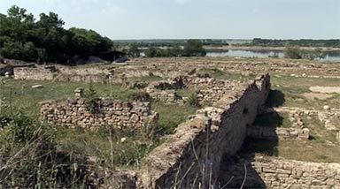
Lower Danube
On the Lower Danube, between the present-day Bulgaria and Romania, a Roman road, the Low Danubian Road, was built during the reign of the Emperor, Tiberius, in the 1st century AD on the right-hand, Bulgarian side of the river.
Roman camps, smaller garrisons and watchtowers were built on both sides of the Danube. Civilian settlements, predominantly for veterans and former legionaries were also built. The following Roman garrisons were the first to be established during the 1st century on the Lower Danube: