
Elevation 1,476 m Parent range Scandinavian Mountains | Prominence 166 m | |
 | ||
Similar Kjerag, Trolltunga, Galdhøpiggen, Gaularfjellet, Gaustatoppen | ||
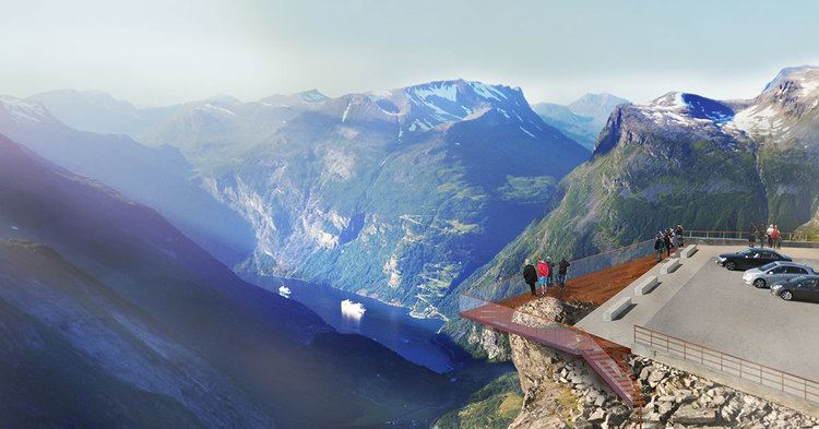
Geiranger Skywalk- Dalsnibba is a mountain in Stranda Municipality in Møre og Romsdal county, Norway. It is located at the end of the Geiranger valley, about 21 kilometres (13 mi) south of the village of Geiranger and the Geirangerfjorden. The 2-square-kilometre (0.77 sq mi) lake Djupvatnet lies directly to the southeast of the mountain. The mountain is located very near the county border with both Oppland and Sogn og Fjordane counties, in the southeastern part of Møre og Romsdal county.
Map of Dalsnibba, 6216 Geiranger, Norway
Dalsnibba offers a very good view and is therefore a very popular tourist destination. Dalsnibba is often covered by snow even in the summer. The Norwegian County Road 63 passes along the south side of the mountain, and from that road, there is a private toll road called Nibbevegen, owned and operated by Geiranger Skysslag, that goes up to the summit of Dalsnibba, it was completed in 1939 but due to the Second World War its official opening where delayed until july 19 1948, and the road was tarmacked in 2013. www.dalsnibba.no www.geirangerskywalk.no
The Geiranger – From Fjord to Summit running and cycling race begins in the village of Geiranger and ends on top of Dalsnibba.