
Topo map NTS O11/E10 Elevation 340 m | Easiest route drive/hike | |
 | ||
Similar Nuttby Mountain, Gully Lake Wilderness Area, Cape to Cape Track | ||
Dalhousie mountain june 21 2014
Dalhousie Mountain is a Canadian peak in the Cobequid Mountains and the highest elevation point in Pictou County, Nova Scotia.
Contents
- Dalhousie mountain june 21 2014
- Map of Dalhousie Mountain Pictou Subd A NS Canada
- Dalhousie mountain ns trail 551
- Wind farm
- References
Map of Dalhousie Mountain, Pictou, Subd. A, NS, Canada
Located north of Trunk 4 west of Salt Springs, the peak is accessible by vehicle using gated roads and is topped by wind turbines and a forest fire surveillance tower.
Dalhousie mountain ns trail 551
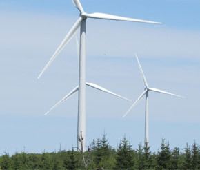
Wind farm
The Dalhousie Mountain Wind Farm was constructed in 2009 at a cost of $130 million and consists of 34 wind turbines with an installed capacity of 51 MW. The turbines are clustered in the vicinity of Dalhousie Mountain as well as on the peak itself. The wind farm is owned by RMSenergy Ltd and is operated as Dalhousie Mountain Wind Farm Operating Limited Partnership.
References
Dalhousie Mountain Wikipedia(Text) CC BY-SA