
Country Philippines Region Ilocos Mayor Belen T. Fernandez | Area 37.23 km2 Population 149,554 (2007) | |
 | ||
Colleges and Universities University of Pangasinan (Dagupan), Lyceum-Northwestern University (Dagupan), University of Luzon, Colegio de Dagupan, STI College - Dagupan (Dagupan) | ||
District 4th district of Pangasinan Similar Baguio, Ilocos Region, Cabanatuan | ||
Map of Dagupan
Dagupan, officially the City of Dagupan (Pangasinan: Siyudad na Dagupan; Filipino: Lungsod ng Dagupan) or simply Dagupan City, is a 1st Class Independent Component City in the province of Pangasinan, Philippines. According to the 2015 census, it has a population of 171,271 people.
Contents
- Map of Dagupan
- Dagupan city mini tour wmv
- Sidneys garden grill the best restaurant in dagupan
- Etymology
- Kaboloan
- Spanish occupation
- Japanese Occupation
- Allied liberation
- Dagupans cityhood
- Geography
- Barangays
- Demographics
- Transportation
- Economy
- Education
- Health
- Media
- Sister cities
- References
Located on the Lingayen Gulf on the island of Luzon, Dagupan is a major commercial and financial center north of Manila. Also, the city is one of the centers of modern medical services, media and communication in Northern Luzon. Dagupan is situated within the fertile Agno River Valley.
The city is among the top producers of milkfish (locally known as bangus) in the province. From 2001-2003, Dagupan's milkfish production totaled to 35,560.1 metric tons (MT), contributing 16.8 percent to the total provincial production. Of its total production in the past three years, 78.5 percent grew in fish pens/cages while the rest grew in brackish water fishpond.

Dagupan city mini tour wmv
Sidneys garden grill the best restaurant in dagupan
Etymology
The city's name was derived from the local Pangasinan word pandaragupan, meaning "gathering place" as the city has been a regional market center for centuries.
Kaboloan
During the 15th century, Pangasinan had been the site of an ancient polity called the Kaboloan. the Wangdom of Pangasinan sent emissaries to China in 1406-1411.
Spanish occupation
The area that is now known as Dagupan was described as marshland thickly covered with mangrove and nipa palm trees. The natives lived along the shoreline and riverbanks of Calmay, Pantal, and Bonuan. But there were also communities in Malued, Lasip, Pogo, and Bacayao. The natives called the area Bacnotan which would later be incorporated into the encomienda of Lingayen that was established in 1583.
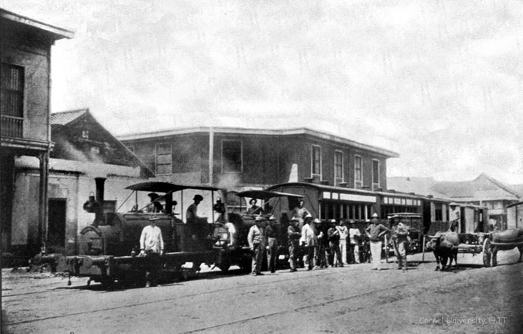
The first long distance railroad in the Philippines connecting Manila and Dagupan was opened on November 24, 1892.
Japanese Occupation
The Japanese planes bombed in Dagupan on December 1941 and through the occupying the Japanese forces on 1942.
Allied liberation
On January 8–January 9, 1945, U.S. General Douglas MacArthur landed his amphibious liberation force in the city's "Blue Beach" section along the Lingayen Gulf. From his beachhead in Dagupan, along with those in neighboring towns Lingayen, Binmaley and San Fabian, MacArthur's forces under General Walter Krueger together with the Philippine Commonwealth troops under the Philippine Army and Philippine Constabulary units were able to penetrate Japanese defenses in Luzon island and liberate Filipino and allied prisoners of war near Cabanatuan in the province of Nueva Ecija, and in Manila's University of Sto. Tomas, among others.
Dagupan's cityhood
Dagupan became a city by virtue of Republic Act No. 170, authored by Speaker Eugenio Pérez. It was signed into law by President Manuel Roxas on June 20, 1947.
The westward expansion of the city went as far as Lucao, which was also swampland. Local historian Restituto Basa surmised that the name Lucao may have been derived from the shellfish called lukan that used to abound in the swampy area.
In June 1962, Dagupan was shaken by a series of strong earthquakes which occurred at irregular intervals for about three weeks. The quakes toppled the belfry of the Roman Catholic Church. Many people from Calmay, Carael and island barrios evacuated to other towns.
In 1968, the national government agencies opened offices in Dagupan and other key cities across the country. The daytime population increased substantially, causing congestion in the city that began to see the appearance of public utility tricycles.
On July 16, 1990, a magnitude 7.7 earthquake struck northern Luzon, causing liquefaction, which made buildings tilt and sink due to their heavy weight and the looseness of the ground, which turned into sediment-rich mud. One of the two bridges, especially Magsaysay Bridge spanning the Pantal River, collapsed, delaying people from crossing to the other banks and vice versa. Major damage caused businesses to be permanently transferred to the neighbouring towns of Mangaldan and Calasiao, but somehow, Dagupan and its inhabitants managed to recover from the earthquake.
Geography
Dagupan City covers a total land area of 4,447.10 hectares (10,989.0 acres),[1] bounded by the Lingayen Gulf in the north, San Fabian in the northeast, Mangaldan in the east, Calasiao in the south and Binmaley in the west. Land use is primarily for agriculture with 35.98% of the total land area, fishpond, cropland, residential with 22.88%; others uses are commercial, industrial, institutional, government private, parks and roads.
Barangays
Dagupan City is politically subdivided into 31 barangays.
Demographics
The Pangasinenses are the predominant people in Dagupan. Pangasinan is the predominant language used in the city.
Transportation
Dagupan is connected with other cities by networks of national roads. Romulo Highway and Pangasinan - La Union Road (N55) and Urdaneta - Dagupan Road (N56) are the principal highways that serve the city.
The Philippine National Railways (PNR) once serves Dagupan through Dagupan station, that went defunct in the late 1980s. The first railroad in the Philippines, the Manila-Dagupan Railway, terminated at the city.
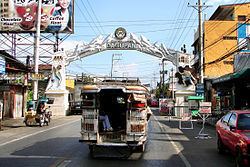
Intercity/interprovincial buses from Manila serve the city, and are usually operated by Dagupan Bus Company, Victory Liner, Five Star, and Pangasinan Solid North. Jeepneys provide
Economy
Dagupan is the economic center of Pangasinan. As a hub, many people in Pangasinan commute to the city during the day. This causes the city's daytime population to rise and cause traffic to areas in the city especially the Downtown Area. The city is a vital financial center housing numerous banks, non-bank financial institutions and offices of some of the government agencies.
Another part of Dagupan's economy is the motor vehicle industry. Many automotive companies have a dealership in the city's metropolitan area. Existing car dealerships include Ford, Hyundai, Chevrolet, Mazda, and Izuzu all found in Dagupan while Toyota, Honda, Mitsubishi, Nissan and many more are found at the neighbouring town of Calasiao.
Education
Since the Spanish time, Dagupan has always been the center of education in Ilocos Region (Region 1). The private sector-driven centers of education University of Pangasinan, University of Luzon and Lyceum-Northwestern University lead, 14 colleges and 18 vocational schools and 3 technical learning centers, 19 secondary schools and 53 elementary schools both in public and private.
Health
Medical and health service centers abound in Dagupan. Out of 51 hospitals in Pangasinan, 12 are located in the city. The largest of these is the Region 1 Medical Center with hospital bed capacity of 600.
Media
Dagupan City is home to regional television stations of GMA Network, CNN Philippines, TV5 and ABS-CBN, sixteen radio broadcasting stations, at least seventeen local newspapers and three cable television companies. There are two news programs TV Patrol North Central Luzon (ABS-CBN TV-32 Dagupan) and Balitang Amianan (GMA Dagupan).