
District Gänserndorf Area code 02538 Elevation 161 m Local time Wednesday 10:55 PM | Time zone CET (UTC+1) Website duernkrut.gv.at Population 2,251 (1 Apr 2009) Postal code 2263 | |
 | ||
Weather 2°C, Wind SE at 5 km/h, 78% Humidity | ||
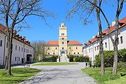
Dürnkrut (Slovak: Kruta, Suchá Kruta, Czech: Suché Kruty) is a market town in the district of Gänserndorf in the Austrian state of Lower Austria. Castle Dürnkrut (pictured) is the most famous landmark of the town. The town is agricultural with some noteworthy businesses. Crops grown in the flatter areas are canola, corn, sunflowers and sugar beets. The rolling hils are planted with wine grapes by local vintners.
Contents
Map of 2263 D%C3%BCrnkrut, Austria
Dürnkrut is located on the March river, which often floods and also forms the border with Slovakia. The last big flood was in 2006, at which time many houses near to the river were flooded with 2 meters of water. Dürnkrut is located on the Austrian Railways Nordbahn line. In former times there was a big sugar factory that made the sugar beets into refined sugar. It was closed down many years ago but some of the buildings are still standing. The wine street offers many old wines.
The sister town of Waidendorf is located 2 km away, and has even more on.