
First ascent 2 September 1858 | Elevation 3,673 m Prominence 324 m | |
 | ||
Normal route via the Refuge des Conscrits Similar Aiguille de Bionnassay, Aiguille de la Bérangère, Aiguille de Tré la Tête, Aiguille du Tour, Dôme du Goûter | ||
The Dômes de Miage are a line of mountain peaks in the south of the Mont Blanc massif that reach a height of 3,673 metres. The snow-covered arête from which they rise is over three kilometres long. The six peaks in the chain are (from southwest to northeast) : L'Aiguille de la Bérangère (3,425 m), and unnamed tops known only from their heights as Dôme 3670, Dôme 3666, Dôme 3633, Dôme 3673 and Dôme 3672.
Map of D%C3%B4mes de Miage, 74170 Saint-Gervais-les-Bains, France
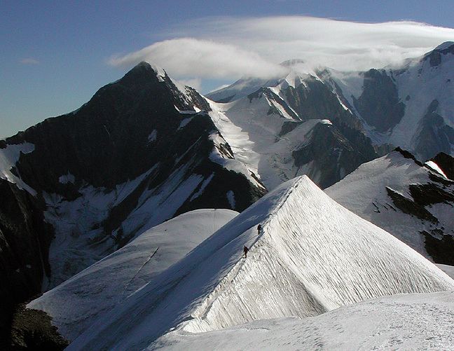
The ridge of the dômes de Miage is considered one of the most striking in the Mont Blanc massif.
The normal route starts at the Refuge des Conscrits, crosses the Tré-la-Tête glacier, climbs to Col des Dômes (between tops 3633 and 3673) and follows the arête as far as La Bérangère (PD). A crossing from end to end runs from the Refuge des Conscrits to refuge Durier and is a little more difficult (AD). It is usually combined with the long traverse over the Aiguille de Bionnassay to Mont Blanc.