
Fatalities 983 total | Affected areas India, Pakistan | |
 | ||
Formed June 21, 2007 (2007-06-21) Dissipated June 26, 2007 (2007-06-27) Highest winds 3-minute sustained: 65 km/h (40 mph)
1-minute sustained: 95 km/h (60 mph) Lowest pressure 986 hPa (mbar); 29.12 inHg Damage $2.1 billion (2007 USD) Date 21 June 2007 – 26 June 2007 Similar Cyclone Phyan, Cyclone Bijli, Cyclone Gonu, Cyclone Keila, Cyclone Onil | ||
Cyclone yemyin
Cyclone Yemyin (JTWC designation: 03B, also known as Cyclonic Storm Yemyin and Deep Depression BOB 03/2007) was a deadly tropical cyclone that made landfalls on India and Pakistan in June 2007. The Pakistan Meteorological Department referred to Tropical Cyclone 03B as "Tropical Cyclone Yemyin". At the time, the official WMO body responsible for tropical cyclones in the Arabian Sea, the India Meteorological Department (IMD), did not name the storm. However, the IMD reassessed the system to have reached cyclonic storm strength, and retroactively named the storm Yemyin.
Contents
- Cyclone yemyin
- Unicef rebuilding in the aftermath of cyclone yemyin
- Meteorological history
- Pakistan
- India
- Afghanistan
- Naming
- References
Throughout three countries, 983 people were killed: 730 in Pakistan, 140 in India and 113 in Afghanistan. In all, the storm wrought roughly $2.1 billion in damage in India and Pakistan.
Unicef rebuilding in the aftermath of cyclone yemyin
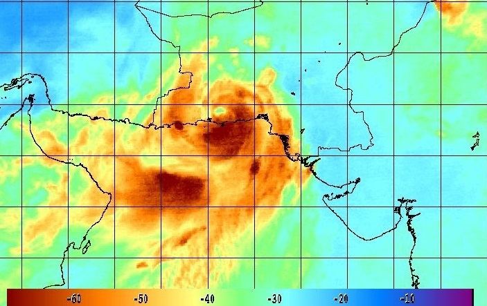
Meteorological history
A low pressure area associated with the monsoon trough was first detected by the Naval Research Laboratory in the Bay of Bengal on June 17. Over the next few days, it developed deep flaring convection near an exposed low-level circulation centre (LLCC) as it drifted in open sea. Despite moderate to high vertical wind shear, the disturbance produced surface pressure falls of up to 2.7 mbar (hPa) in Port Blair, in the Andaman Islands, on June 19. Convection persisted around the increasingly well-defined LLCC, and the disturbance continued to consolidate under favourable diffluence.
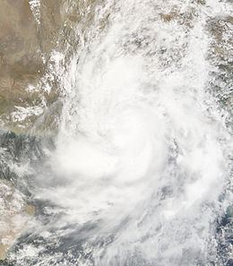
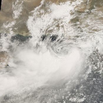
Early on June 21, the India Meteorological Department (IMD) declared the area a depression, 430 km (270 mi) east-southeast of Kakinada, Andhra Pradesh, India. Several hours later, the Joint Typhoon Warning Center (JTWC) issued a Tropical Cyclone Formation Alert (TCFA), with winds near 30 kn (55 km/h, 35 mph). The depression moved quickly west-northwest towards the northern Andhra Pradesh coast. A subtropical ridge to the north weakened the wind shear which had been paralysing the system, allowing for further intensification. Later that day, the IMD upgraded the system to a deep depression. As convection organised with increasing ocean heat content, the JTWC issued its first warning on Tropical Cyclone 03B. The deep depression made landfall near Kakinda early on June 22 local time. The JTWC issued its final advisory later, as the system began to weaken due to land interaction and wind shear. The next day, the IMD downgraded it to a depression while it crossed the Deccan Plateau. The final warning was issued on June 24, despite the storm having moved into the Arabian Sea.
The JTWC noted in its Significant Tropical Weather Outlook for the North Indian Ocean on June 24 that strong monsoonal low-level flow contributed to increased cyclonic vorticity, with low vertical wind shear and warm sea surface temperatures. It warned that these factors could lead to a rapid regeneration of the cyclone. Early on June 25, the JTWC issued the second TCFA for this system as its LLCC crossed the coast into the Arabian Sea. Shortly after, both the IMD and the JTWC resumed advisories on the depression.
As it moved northwest just off the Pakistani coast, winds of about 26 kn (48 km/h, 30 mph) and a surface pressure of 990 mbar (hPa) were observed in Karachi near midday on June 25. According to the PMD, the centre of the system reached within 90 km (55 mi) of Karachi. With favourable conditions and deep convection, the system intensified into a deep depression that day. After further organization, it made its second landfall at about 0300 UTC June 26 along the Makran coast, near Ormara and Pasni, Balochistan province, in southwestern Pakistan. Upon reaching land, the cyclone began to weaken slowly, and the JTWC issued its last advisory late on June 26.
Pakistan
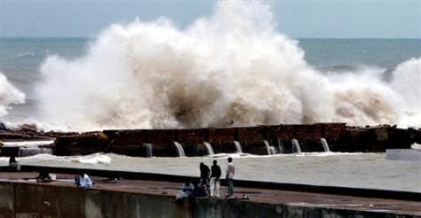
In Karachi, Pakistan, about 213 people died from rains and winds of 111 km/h (69 mph) that might have been associated with an outer band of the cyclone. The Pakistan Meteorological Department (PMD) had warned of heavy rains and wind from the system as early as Friday June 22.
The cyclone trapped 2 merchant ships: Al-Picaso and Lady Hamad, and 4 fishing boats: Al-Taif, Al-Noor, Sumbal Sultani and Al-Tariq, 100 nmi (185 km, 115 mi) off Karachi. The Pakistan Navy rescued 56 sailors from the merchant ships and 36 fishermen from the fishing boats after they were detected by Breguet Atlantique aircraft. The heavy downpour also flooded the Kech Korandi riverine, inundating the city of Turbat and causing more than 10,000 people to evacuate their houses. At least 380 people died in Balochistan, with another 250 dead in Sindh and 100 in the North-West Frontier Province, and further rains associated with the remnants of the cyclone hampered rescue efforts. The cyclone affected at least 10 districts of Balochistan and 4 districts of Sindh, affecting the lives of atleas 1.5 million people. At least 2 million people were affected by the cyclone. More than 2 million livestock, worth over 4 billion rupees, were killed by the storm.
India
The storm killed at least 140 people in India, while it was still in the Bay of Bengal Property losses from the storm were estimated at 24 billion rupees.
Afghanistan
Over 80 people were killed in floods associated with the remnants of Yemyin in Afghanistan.
Naming
The PMD referred to the deep depression as Tropical Cyclone Yemyin, the next name on the list at the time. The IMD, the official Regional Specialized Meteorological Centre for the North Indian Ocean, did not operationally upgrade or name the system due to intense Indo-Pakistani relations. However, on August 6, the IMD reassessed the deep depression to have reached cyclonic storm strength, and retroactively designated the system as Cyclonic Storm Yemyin in its mid-season review. This was confirmed by the designation of Cyclonic Storm Sidr, the next name on the list after Yemyin, in November.