
Formed April 14, 2009 Fatalities 4 direct, 3 indirect | Dissipated April 17, 2009 | |
 | ||
Highest winds 3-minute sustained: 75 km/h (45 mph)1-minute sustained: 95 km/h (60 mph) Lowest pressure 996 hPa (mbar); 29.41 inHg Date 14 April 2009 – 17 April 2009 Similar Cyclone Phyan, Cyclone Yemyin, Cyclone Akash, Cyclone Rashmi, Cyclone Aila | ||
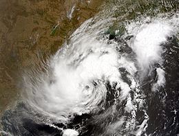
Cyclone bijli as on 17 apr 09
Cyclone Bijli (JTWC designation: 01B, also known as Cyclonic Storm Bijli), was the first tropical cyclone to form during the 2009 North Indian Ocean cyclone season. Cyclonic Storm Bijli formed from an area of Low Pressure on April 14. Later that evening, RSMC New Delhi upgraded the Low Pressure into a Deep Depression. Joint Typhoon Warning Center issued a Tropical Cyclone Formation Alert and designated Bijli as Tropical Depression 01B. While RSMC New Delhi designated it as Deep Depression, during the morning on April 15. Later that day, both RSMC New Delhi and Joint Typhoon Warning Center issued full warnings on Bijli as it intensifies to a Tropical storm. They also classified Bijli as a Tropical cyclone on that day. But on the morning of April 17, RSMC New Delhi downgraded cyclone Bijli into a deep depression Due to land interaction. However, on April 18, RSMC New Delhi continues to issue warnings on Bijli as it moves toward Northern Myanmar (Burma). The word Bijli refers to lightning in Hindi.
Contents
Meteorological history
On April 13, an area of shower and thunderstorms became slightly organized over the central Bay of Bengal. Later that day, an area of low pressure developed underneath the convection as the system developed. Weak banding features also formed around the periphery of the storm. By April 14, deep convection persisted around the center of circulation; following the development the RSMC in New Delhi, India designated the system as Depression BOB 01. Following further development, the Joint Typhoon Warning Center (JTWC) issued a Tropical Cyclone Formation Alert (TCFA) as they anticipated the system to develop into a tropical storm. Early the next morning the JTWC reported that the depression had intensified into a tropical storm and designated it as Cyclone 01B. The storm tracked towards the west-northwest due to a mid-level ridge over India. Later that morning RSMC New Delhi reported that the depression had intensified into a deep depression and reported it was expected to intensify into Cyclonic Storm Bijli. Around 1500 UTC, the RSMC New Delhi upgraded the system to a cyclonic storm and gave it the name Bijli. Partial convective banding developed around the periphery of the system as it intensified. The conditions for good outflow were present but did not develop. Around this time, the forward motion of the storm also slowed. On April 16, the storm turned towards the northeast, paralleling the eastern coast of India. Around 0600 UTC, RSMC New Delhi reported that Bijli had reached its peak intensity with winds of 75 km/h (45 mph 3-minute winds). Early on April 17, RSMC New Delhi reported that Bijli had weakened into a deep depression as it started to move the northeast.
India
All four parts in Odisha were placed on high alert due to rough seas produced by the storm. A Local Cautionary Signal Number Three was issued for the Gopalpur, Puri, Paradeep and Chandabali ports. Heavy rain from thunderstorms fell in Andhra and Orissa due to the outer bands of Bijli. Winds up to 55 km/h (35 mph) were also reported along the coast.
Bangladesh
In Bangladesh, at least 40,000 volunteers from the Bangladeshi Red Cross were placed on standby in case evacuations were required. Bangladeshi officials urged all ports to be on high alert and all fishermen to stay at port. The warning signal was placed at No. 3 on a scale of 1 to 10, with 10 being the highest level of warning. Thousands of residents on Moheshkhali Island evacuated to 80 shelters. As the storm neared landfall, ports in Chittagong raised their warning level to seven. Following the increased warning level, an estimated 10,000 evacuated from coastal regions. Weather officials estimated that the storm would produce a storm surge of 2.1 to 3 metres (7 to 10 ft). On April 17, all flights in and out of Bangladesh were cancelled due to dangerous conditions. Shelters were also opened and were reportedly able to accommodate about one million people. In Chittagong, 6,000 volunteers set up to assist in the aftermath of the storm and about 283 medical teams formed within the group. An estimated 200,000 people evacuated from Chittagong and the Cox's Bazar District before the storm made landfall.
The Tropical Rainfall Measuring Mission satellite, jointly operated by NASA and JAXA, estimated that Bijli produced a maximum of 129 millimetres (5.1 in) of rain over coastal Bangladesh, with rainfall rates reaching nearly 50 mm/h (2 in/h). High winds downed several trees; numerous homes sustained damage and several ships on offshore islands were reportedly caught in the storm. High winds and heavy rains have also knocked out power to some communities. A storm surge of 2.1 m (7 ft) was recorded in the Cox's Bazar District with reports higher amounts in localized areas. At least 12 huts, 50 betel beef fields, and a large amount of salt have been damaged by the storm. Later reports indicated that thousands of homes have been damaged or destroyed by the storm. The first fatality caused by Bijli occurred when a tree knocked down by high winds fell on a 9-year-old boy, killing him on impact and injuring his sister. In the Cox's Bazar District, a school teacher and two students were killed. One of the two children was trampled to death during the evacuation. The other child was killed when his home collapsed on top of him.
During the evacuation, a 48-year-old man collapsed and died after suffering a heart attack. His child, who was only a few months old, also died from medical circumstances which were aggravated during the evacuation. In all, the storm destroyed 500 thatched houses and 1,500 betel leaf plantations and flooded about 70,000 acres (280 km2) of cropland. Throughout Bangladesh, seven people were killed and 84 were injured. A total of 702 homes were destroyed and more than 3,825 others were damaged as well as 3,636 acres (14.71 km2) of agricultural land. In the Cox's Bazar District, 607 heads of cattle drowned during the storm. Following the impacts of Bijli, the Government of Bangladesh allocated Tk. 79,000 (US$1,147) in assistance to affected population. The Department of Relief and Rehabilitation in Bangladesh provided 450 metric tonnes of rice to four districts, 200 of which was sent to Chittagong. To prevent an outbreak of post-storm diseases, the World Health Organization deployed 1,105 medical teams to the country.
Myanmar
A storm surge of 1.8 to 2.4 m (6 to 8 ft) was also expected to impact coastal areas of Myanmar close to the Bangladeshi border. An estimated 6,000 fishing trawlers were to return to port by the afternoon of April 17. Following the devastating results of Cyclone Nargis almost a year prior, officials in Myanmar urged residents along the coast to evacuate. Thousands of residents living in rural villages sought shelter in inland towns along the coast of Myanmar. The entire village of Aukpyunewa evacuated after hearing about an approaching cyclone on the radio. According to local residents, "We are taking precautions unlike earlier" in reference to the large loss of life due to Cyclone Nargis. The storm produced little or no storm surge in Myanmar as it made landfall; however, the remnants of Bijli produced heavy rains over northern areas of the country before the storm dissipated.