
Formed May 15, 1986 Damage $25 million (1986 USD) Date 15 May 1986 – 22 May 1986 | Dissipated May 22, 1986 | |
 | ||
Highest winds 10-minute sustained: 150 km/h (90 mph)1-minute sustained: 155 km/h (100 mph) Lowest pressure 955 hPa (mbar); 28.2 inHg Fatalities 150 reported, 111 confirmed Similar Cyclone Tia, Cyclone Trina, Cyclone Anne, Cyclone Sose, Cyclone Esau | ||
Severe Tropical Cyclone Namu was considered to be the worst tropical cyclone to have affected the Solomon Islands on record. On May 15, 1986, a tropical depression formed within the monsoon trough. Located north of the Solomon Islands, the storm steadily intensified while meandering. After briefly moving west, the storm attained Category 2 intensity on the Australian intensity scale on May 18 as it moved through the island chain the next day. Cyclone Namu attained peak intensity of 120 km/h (75 mph). After keeping peak intensity for a day, Namu turned south and weakened steadily. By May 21, the winds of Cyclone Namu had been reduced to only 80 km/h (50 mph). Continuing to weaken, Namu turned east and dissipated the next day away from the island chain.
Contents
The storm's slow motion allowed for prolonged periods of heavy rainfall, resulting in phenomenal flooding across the Solomon Islands. The islands of Malaita and Guadalcanal experienced the most significant damage from Namu. Coastal areas of the former were severely damaged by rough seas and strong winds, especially along the eastern side where entire villages were destroyed. Meanwhile, on the island of Guadalcanal, a village of 43 people had only 5 survivors. Moreover, Cyclone Namu flooded 75% of the Guadalcanal's plains. In addition, 22% of homes were either damaged or destroyed on the island.
Across the Solomon Island group, schools, buildings, electricity, water supplies, roads, communication systems, forests, and agriculture sustained widespread damage. In some regions, nearly all homes were destroyed. Mudslides destroyed roads, bridges, water pipes and drainage systems. Crops such as cocoa, copra, coffee, and rice were destroyed. Villages throughout the entire island group sustained severe damage. Overall, approximately 90,000 people, one third of the country's population, were reported as homeless. In all, Cyclone Namu was responsible for at least 150 deaths, mostly from flooding and landslides. Property damage and economic losses across the Solomon Islands totaled $25 million and $100 million (1986 USD) respectively. During the aftermath of the storm, the government of the Solomon Islands declared a national state of emergency. Meanwhile, the United Kingdom, Papua New Guinea, the United States, and Japan also sent supplies and goods to the Solomon Islands.
Meteorological history
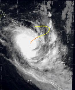
On May 15, 1986, the Fiji Meteorological Service (FMS) started to monitor a tropical depression that developed within the monsoon trough in association with Typhoon Lola about 90 km (55 mi) to the north of Malaita. Over the next two days, the system moved towards the southeast before recurving to the southwest as it showed signs of developing further. During May 17, the Joint Typhoon Warning Center (JTWC) started to issue warnings on the system, designating it as Tropical Cyclone 33P after the system had developed winds equivalent to a tropical storm. At 2100 UTC that day, FMS named the depression Namu, after it had acquired the characteristics of a tropical cyclone and become equivalent to a modern-day Category 2 tropical cyclone on the Australian tropical cyclone intensity scale with 10-minute sustained windspeeds of 100 km/h (65 mph).
During May 18, the system continued to intensify and developed a broad and ragged eye as it moved towards the southwest, before it passed over Manawai around 1400 UTC. Later that day as Namu approached Guadalcanal, FMS reported that the system had peaked in intensity with 10-minute sustained windspeeds of 150 km/h (90 mph), which would make it equal to a Category 3 severe tropical cyclone on the Australian scale. Around this time the JTWC, reported that Namu had peaked with 1-minute sustained windspeeds of about 155 km/h (100 mph), which made it equivalent to a Category 2 hurricane on the Saffir-Simpson hurricane wind scale as it moved slowly through the Solomon Islands. Namu remained at its peak intensity as it slowly moved away from the Solomon Islands for 24 hours when it moved across 160°E into the Australian region. The next day the system gradually recurved towards the south-southeast while gradually weakening. During May 21, Namu moved back into the South Pacific basin. The next day, Namu dissipated north of New Caledonia after it had become sheared within the middle levels of the atmosphere.
Preparations and impact
Severe Tropical Cyclone Namu was considered to be the worst tropical cyclone to affect the Solomon Islands on record and the most serious natural disaster in living memory. The system impacted the island nation between May 16–19, with heavy rainfall contributing to over 100 deaths and extensive damage on the islands. As a result of the impact on the Solomon Islands the name Namu was later retired from the lists of tropical cyclone names for the region and retired. Ahead of the system impacting the islands various tropical cyclone warnings were issued by the Solomon Islands Meteorological Service and broadcast in English and pidgin by the Solomon Islands Broadcasting Corporation. However, many people were caught off guard by the cyclone's sudden increase in winds and the prolonged heavy rain, especially in remote areas where weather forecasts were difficult to disseminate because of communication problems.
The storm's slow motion allowed for prolonged periods of heavy rainfall, with Honiara International Airport measuring 340 mm (15 in) of rain over a three-day period. Hurricane or storm force winds affected Malaita, Small Malaita, Guadalcanal, Bellona, and other smaller islands that the cyclone's center passed within 50 to 65 km (30 to 40 mi). Gale-force winds covered a wide area, extending as far north as the northern tip of Malaita and as far south as San Cristóbal. Gusts in some areas were estimated to be as high as 185 km/h (115 mph). On the islands of Bellona and Rennel, strong winds resulted in devastation. The storm was estimated to have caused a maximum wave height of 1.5 m (4.9 ft).
Most of the damage caused by Cyclone Namu occurred due to river flooding. The cyclone affected 48% of the Solomon's land area and 62% of its total population. Even though there are few rivers in the Solomon Islands, the ones that do exist are shallow and flood easily. Of all the islands, Malaita was the worst affected by the cyclone due to Namu's rough seas and strong winds. Along the eastern coast of the island, damage was massive; entire villages were destroyed. Gardens were devastated and walking pathways were blocked. On Sikiana Island, a small island with a few hundred residents, only one house was left standing. In Babanakira, 5 people died.
On the island of Guadalcanal, a single mudslide was responsible for killing 38 villagers. Of the 43 people that lived in the small town of Valebaibai, only 5 survived, all of whom narrowly escaped. Moreover, 14 dead bodies were found in the central and southern areas of Guadalcanal on May 21 when flood waters began to recede.
Deep flood water covered 75% of the island's (Guadalcanal) coastal plain; these waters cut off channels and destroyed coastal villages. Furthermore, the Lungga, Ngalimbiu, Mberande, and Nggurambusu rivers sustained the worst flood damage; water depth in some of the aforementioned rivers reached 8 m (26 ft). Many trees were brought down due to high winds. Also, numerous plantations were destroyed across the island. However, little beach erosion occurred on the island. Moreover, 22% of homes on the island were either damaged or destroyed. One bridge was also destroyed on the island. Offshore Honiara, the capital of the nation, two ships [one was 60 ft (20 m) long and the other was 120 ft (35 m) long] each sank during the storm. Throughout the capital, several schools were destroyed. The two bridges that connected the city with the island of Guadalcanal were destroyed, thus leaving Honiara isolated. Furthermore, about 5,000 homeless were left homeless across the city, 2,000 of whom sought refuge in a local college due to the storm. Although no people were to have confirmed to have died in the city, five children were reported missing in one of the capital's suburbs, Ngalimera.
In both Guadalacal and Malatia, extensive areas of irrigated rice crops were submerged under floodwaters and mud. In some areas, nearly all homes were destroyed. Mudslides and logs destroyed roads, bridges, water pipes and drainage systems. Crops such as cocoa, copra, coffee, and rice were destroyed, resulting in thousands of dollars in damage. Although there are no reports of storm surge throughout the islands, it is likely that coastal areas suffered damage from surge. Additionally, communication between the outer and island of the Solomon group was completely destroyed.
In all, approximately 90,000 people, one third of the country's population, were reportedly homeless. The southern islands of the Solomon's chain were seriously affected by the passage of Namu, becoming the worst tropical cyclone to impact the area in five years. Of the 25,000 "traditional" houses on the Solomon Island, 6,000 (26%) were destroyed. Overall, Cyclone Namu is "positively identified" to have killed 111, some reports suggest at least 150 people perished due to Namu. Most of the fatalities were due to landslides and flooding. Property damaged totaled $25 million (1986 USD) and the storm also caused US $100 million in economic losses in the Solomon Islands. On May 18, Honiara's Central Hospital authorities decided to evacuate several patients, as the hospital was located on a coastal strip that was vulnerable to river flooding and seawater inundation.
Aftermath
During May 19, the Government of the Solomon Islands declared a state of national disaster and decided that the emergency period would run until May 31. As a result, the government started to ask bilateral donors including Australia, New Zealand and the United Nations for assistance. However, before any foreign assistance could arrive in the Solomon Islands, residents started to try to help themselves by patching up water pipes with bamboo, string and rubber strips. New Zealand subsequently donated an initial 7006100000000000000♠NZ$1 million, while the Australian High Commission subsequently donated an initial 7006120000000000000♠AU$1.2 million worth of relief supplies. This included two C-130 Hercules cargo planes from the Royal Australian Air Force, a detachment party, relief supplies and two Iroquois helicopters. These aircraft arrived during May 21, when Henderson Field Airport reopened for emergency operations, after flood waters had receded and the mud and debris had been removed.
Within a week following the storm, access to fresh water was resorted to the archipelago; doctors believed that had these services not been restored, widespread disease would have been reported. The government declared June 2 a national day of mourning for the victims of the storm.
The International Monetary Fund loaned $1.3 million USD to the nation. Australian relief planes had dropped food to 4,000 victims in the highlands on the main island of Guadalcanal and New Zealand provided nearly 30,000 lb (13,610 kg) of rice, canned meat and tea to the devastated region. New Zealand engineers were brought in to assess damage to roads and bridges and start removal of 40 ft (10 m) high debris along the waterfronts of the island chain. Also, $10,000 ECU was donated to the devastated island group. Other countries, including the United Kingdom, Papua New Guinea, the United States, and Japan also sent supplies and goods to the Solomon Islands. Overall, $8.6 million USD was provided to the Solomons and 71,000 lb (32,205 kg) worth of supplies were provided to victims of the cyclone.
During May 26, Henderson Field was reopened for commercial flights
Moreover, a commercial aircraft provided supplies to the 200 inhabitants of Sikiana Island, which had run out of food a week after the storm. In all, a total of 17 coastal trading vessels, four helicopters, and six aircraft were used to transport food, tents and medical supplies to the needy. It was estimated that the homeless would require aid such as food for six months.
Elsewhere, in Honiara, the local ministry asked each resident to pay $50 so that the roofs that were damaged by the system could be repaired. The cleanup process took a long time; a year after the storm, bulldozers were reportedly still removing broken logs and not all roads had been repaired. Following the storm, disease spread to isolated part of the Solomon Island group; many animals died and hundreds of children were hospitalized because of the outbreak of disease.
On June 4, the Government of the Solomon Islands lifted the emergency period, four weeks after the system had impacted the islands. After the emergency period was lifted, outside assistance that had been brought in to assist with relief efforts were gradually withdrawn, including armed services from Australia and New Zealand. However, external assistance from Australia and New Zealand amongst others, was still needed due to the Solomon Islands reliance on overseas aid in general. As a result, a two-day meeting took place in Honiara during July, at which the Solomon Islands Government requested and was promised about 7007135000000000000♠13.5 million for 20 rehabilitation programs. Pledges of assistance were made by Australia, Britain, New Zealand, the European Economic Community and agencies of the United Nations and the United States of America. These programs included projects to replace rural primary schools flattened by the cyclone, bridges and water supply systems swept away by Namu.
During March 1987, volunteers from the Australian Rotarians, commenced an eighteen-month project to build 93 schools in the Solomon Islands.
Questions were raised during the systems aftermath over whether or not excessive deforestation worsened the impact of the flood. The government denied reports that deforestation had any link to the catastrophe.