
Formed 1 April 2003 (2003-04) | Fatalities 58 direct | |
 | ||
Dissipated 8 April 2003 (2003-04-09) Highest winds 10-minute sustained: 240 km/h (150 mph)1-minute sustained: 260 km/h (160 mph)Gusts: 335 km/h (205 mph) Lowest pressure 900 hPa (mbar); 26.58 inHg(Record low in Australian region) Damage ~ $6 million (2003 USD) Date 1 April 2003 – 8 April 2003 Similar Cyclone Gwenda, Cyclone Herbie, Cyclone Fay, Cyclone Magda, Cyclone Thelma | ||
Cyclone Inigo was the most intense recorded cyclone in the Australian region. It developed from a tropical low that crossed eastern Indonesia in late March 2003. Becoming a named tropical cyclone on 1 April, Inigo rapidly intensified as it tracked southwestward, reaching a minimum central pressure of 900 hPa on 4 April. An approaching trough weakened the cyclone and turned it to the southeast, and on 8 April Inigo dissipated after making landfall on Western Australia as a minimal tropical storm.
Contents
The precursor disturbance dropped heavy rainfall across eastern Indonesia, causing widespread flooding and mudslides. The worst of the damage was on Flores island, though damage was also reported on West Timor and Sumba. The flooding and mudslides damage or destroyed thousands of houses, forcing many to leave their homes. A total of 58 casualties were reported in association with the disturbance. In Australia, Inigo produced locally heavy rainfall, but little damage.
Meteorological history
By 26 March, an area of disturbed weather was located within the near-equatorial trough near Papua New Guinea. Initially located within an area of easterly wind shear, it tracked westward due to the presence of a ridge to its south, and on 27 March a low pressure area formed over Western New Guinea. Thunderstorm activity increased around a mid-level circulation as it crossed into the Arafura Sea, and its overall organisation continued to increase. On 29 March, a low-level circulation was visible, though significant tropical development was prevented due to wind shear and land interaction with islands in the Indonesian archipelago. It developed into a tropical low on 30 March, and after turning to the southwest, it crossed the island of Flores on 31 March; upon doing so its convection greatly increased due to increased upper-level divergence, which produced heavy rainfall on Flores and Timor. On 1 April, wind shear decreased as it crossed into the Savu Sea, and by early on 1 April it developed into a tropical cyclone to the northeast of Sumba.
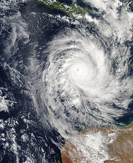
At 1200 UTC on 1 April, the Joint Typhoon Warning Center (JTWC) issued its first advisory on the system, classifying it as Tropical Cyclone 26S. At 0000 UTC on 2 April, the Bureau of Meteorology (BOM) warning centre in Perth classified the low as Tropical Cyclone Inigo. The storm quickly intensified as it tracked southwestward, aided by low wind shear and strong divergence. An eye featured gradually organised, and early on 3 April the BOM classified Inigo as a severe tropical cyclone with winds of 80 mph (130 km/h). Later that day, the cyclone underwent rapid intensification as the eye became increasingly better defined. On 4 April, Inigo attained Category 5 status on the Australian cyclone scale, and at 0600 UTC it reached peak winds of 240 km/h (150 mph) and an estimated minimum pressure of 900 hPa (mbar) while located about 950 km (590 mi) north of Onslow, Western Australia. Around the same time, the JTWC assessed Inigo as a powerful cyclone with 1-min winds of 260 km/h (160 mph). With a minimum pressure of 900 hPa, Inigo tied Cyclone Gwenda of the 1998–99 season as the most intense tropical cyclone on record in the Australian cyclone region.
Upon reaching peak intensity, Inigo maintained an eyewall 32 km (20 mi) in diameter. Late on 4 April, an approaching upper-level trough increased wind shear over the system, which caused a steady weakening trend. On 5 April, the eye became cloud-filled, and later that day the cyclone reached its westernmost point before the approaching trough turned it to the southeast. By 7 April, its winds decreased to below severe tropical cyclone status, or below 120 km/h (75 mph). The convection continued to decrease, leaving the centre exposed from the convection as it made landfall early on 8 April in the Pilbara region of Western Australia. Upon moving ashore, Inigo had winds of around 75 km/h (45 mph), and the circulation dissipated within 12 hours after moving ashore.
Impact
The precursor tropical disturbance dropped heavy rainfall in eastern Indonesia; on the island of Flores, Larantuka recorded 223 mm (8.78 in) in a 24‑hour period. The rainfall caused flash flooding and mudslides, primarily in Flores but also on West Timor and Sumba. In some locations, the depth of the floodwaters reached 5 meters (16 ft). The Oessao River in West Timor exceeded its banks, which flooded seven villages. In Kupang in West Timor, the system destroyed hundreds of homes and large fields of corn, bean, and rice crop. Heavy damage was reported near Ende, where flooding and mudslides destroyed 20 houses and destroyed the roads connecting to East Flores. In Ende, a total of 294 animals were killed. The city's airport was flooded with one meter (3 ft) of water, preventing aerial transportation and leaving the city temporarily isolated. In East Flores Regency in eastern Flores Island, the system left 75 destroyed houses, along with 77 severely damaged and a further 56 receiving light damage. Damage in Indonesia totalled less than $6 million (2003 USD, $6.8 million 2007 USD), and 102 injuries were reported. The Indonesian representative to the Tropical Cyclone Committee of the World Meteorological Organization in 2004 reported the death toll related to the disaster in Indonesia as 58 fatalities.
Additionally, the precursor disturbance produced rough seas along the coastlines, which resulting in the sinking of 12 sailing vessels. Two ships, each with a crew of five to eight people, were reported missing to the southwest of Sumba after Cyclone Inigo passed over their location on 3 April.
Inigo moved ashore on Australia as a weak tropical cyclone, though several locations reported winds of near gale force. The storm dropped light to moderate precipitation near where it made landfall which peaked at 226 mm (8.90 inches), of which 128 mm (5.04 in) of rain fell in 80 minutes. No casualties or significant damage was reported in the country.
Aftermath
Shortly after the storm passed through Indonesia, local government and Red Cross officials distributed assistance to the storm victims, including food, medicine, clean water, and mattresses; additionally, the government sent about $400 million (2003 IDR, $50,000 2003 USD). The affected citizens resided in temporary shelters, including schools, police offices, and shelters built by local governments. Officials deployed machines to remove debris from the roads affected by the landslides.
As a result of its damage, the name Inigo was retired subsequent to its usage; its name was replaced with Iggy.