
Formed December 15, 2006 Fatalities 11 direct, 1 missing | Dissipated December 28, 2006 | |
 | ||
Highest winds 10-minute sustained: 205 km/h (125 mph)1-minute sustained: 250 km/h (155 mph)Gusts: 285 km/h (180 mph) Lowest pressure 930 hPa (mbar); 27.46 inHg Date 15 December 2006 – 28 December 2006 Similar | ||
Intense tropical cyclone bondo 2006 infrared satellite animation hd
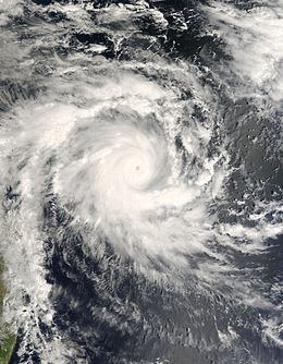
Intense Tropical Cyclone Bondo was a very strong tropical cyclone that was the first of a series of five cyclones to impact Madagascar during the 2006–07 South-West Indian Ocean cyclone season. Originating from an area of low pressure, associated with developing convection, on December 14, the precursor to Bondo initially tracked south-westward into a region of low wind shear and warm sea surface temperatures. Once in this region, the system began to quickly intensify, becoming a tropical storm on December 18. Throughout the day, the storm underwent an extreme period of rapid deepening known as explosive intensification. By the afternoon of December 19, Bondo attained its peak intensity with winds of 205 km/h (125 mph ) and a barometric pressure of 930 hPa (mbar) according to Météo-France. At the same time, the Joint Typhoon Warning Center assessed the storm to have attained an intensity equivalent to a high-end Category 4 hurricane on the Saffir–Simpson Hurricane Scale with winds of 250 km/h (155 mph ).
Contents
- Intense tropical cyclone bondo 2006 infrared satellite animation hd
- Passage du cyclone bondo
- Meteorological history
- Impact and aftermath
- References
After attaining this intensity, the storm underwent an eyewall replacement cycle and weakened. Once this cycle completed, Bondo briefly re-intensified before stalling north of Madagascar. As a result of the system's stalling, sea surface temperatures underneath the storm cooled due to upwelling. The cyclone gradually moved south-southwest and once more intensified to an intense tropical cyclone. However, due to the proximity to land, weakening occurred before Bondo made landfall in western Madagascar as a low-end tropical cyclone with winds of 120 km/h (75 mph 10-minute sustained) on December 25. The storm quickly after moving inland. The following day, Bondo weakened to a tropical depression shortly before moving into the Mozambique Channel. The remnants of Bondo eventually dissipated on December 28 over open waters.
Although a powerful cyclone, Bondo caused moderate damage in northern and western Madagascar. Few reports of destroyed homes were released; however, 11 fatalities are attributed to the storm as well as another missing person. The damage wrought by the storm was compounded and worsened over the following months after four other cyclones struck the country, killing hundreds more and leaving several hundred million dollars in losses.
Passage du cyclone bondo
Meteorological history
An area of convection was first spotted on December 15 west-southwest of Diego Garcia. Moving west, it gained some organisation, causing the JTWC to issue a TCFA on it. It was designated a tropical disturbance on December 17 by Météo-France. The JTWC upgraded it to a tropical cyclone on December 18, and later that day Météo-France upgraded the storm to a moderate tropical storm. The Subregional Tropical Cyclone Advisory Centre in Mauritius named the storm Bondo, a name contributed to the list by Malawi. Following a quick bout of intensification, on December 19 MF reported that Bondo had strengthened into a severe tropical storm. At the next advisory, MF reported that Bondo had undergone rapid intensification, breaking Dvorak rules, and upgraded it to tropical cyclone intensity. The JTWC noted that the tropical cyclone had "intensified at a greater than climatological rate" due to good radial outflow as it upgraded the storm from an equivalent of a strong tropical storm at 0300 UTC December 19 to a Category 3-equivalent at 1500 UTC.
Further strengthening that day saw Bondo upgraded to an intense tropical cyclone, peaking at 205 km/h (125 mph 10-minute sustained) and 930 hPa. After going through an eyewall replacement cycle, the storm began to weaken. Continuing to track south-southwestward as it weakened, it crossed an area of lower vertical wind shear and began to restrengthen near the northern tip of Madagascar on December 23. Moving south-southwest parallel to the coast of Madagascar, it reached a secondary peak of 75 knots (139 km/h) from Météo-France before starting to weaken as it was about to make landfall. It made landfall around 1215 UTC, and the JTWC declared the storm dissipating over land at 1800 UTC, while Météo-France designated the storm as an inland depression. On December 26 M-F reported that the original low associated with Bondo had dissipated and a new low had formed associated with the system over sea. The RSMC La Reunion stopped issuing advisories later that day.
Impact and aftermath
In response to the danger from Bondo, the Farquhar Atoll, which is part of the Seychelles, evacuated 35 of its 43 residents. The remaining eight stayed on the island in a concrete bunker. The island of Agaléga received at least 11 inches of rain from Bondo. Eleven people were killed as a result of Bondo and another was reported as missing. A total of 20,001 people were left homeless. One of the fatalities took place in Mahajanga after a wall collapsed on a man. Another fatality occurred offshore after a man went missing while taking his family canoeing. Roughly 300 people were affected in the city of Mahajanga alone. Phone service and essential equipment were unavailable or out of service in the affected region, hampering rescue efforts. The outer bands of Bondo also brought gusty winds, recorded up to 45 km/h (28 mph) and moderate rainfall.
In conjunction with the International Red Cross, rescue teams in Madagascar were deployed to the hardest hit regions on December 27. These teams traveled by road to the region while a third team was set to arrive by helicopter several days later. By late-February, 2007, the Government of Norway provided $800,000 in relief funds for the combined effects of Cyclones Bondo, Favio and Clovis. On March 15, 2007, the United Nations announced a funding program after three other storms had struck Madagascar. The goal was to provide roughly $9 million to about 300,000 of the millions of affected population. However, upon the announcement, only $3 million of this fund had been allocated. Following the widespread damage from Cyclone Indlala in March, 2007, the Government of Madagascar launched an appeal to the United Nations for $246 million in relief funds for damage wrought by all five cyclones.