
Airport type Public Elevation AMSL 3,854 ft / 1,175 m 5/23 5,299 Elevation 1,175 m | Website CutbankAirport.org Code CTB Owner Cut Bank | |
 | ||
Location | ||
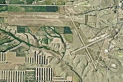
Cut Bank Municipal Airport (IATA: CTB, ICAO: KCTB, FAA LID: CTB) is three miles southwest of Cut Bank, in Glacier County, Montana. It is owned by Cut Bank and Glacier County.
Contents
The airport's website calls it Cut Bank International Airport. Its first flight was on 1 June 1941.
Facilities
Cut Bank Municipal Airport covers 1,730 acres (700 ha) at an elevation of 3,854 feet (1,175 m). It has two asphalt runways: 5/23 is 5,299 by 75 feet (1,615 x 23 m) and 13/31 is 5,300 by 75 feet (1,615 x 23 m).
In the year ending August 22, 2008 the airport had 5,800 aircraft operations, average 15 per day: 90% general aviation, 9% air taxi and 2% military. 32 aircraft were then based at the airport: 88% single-engine, 3% multi-engine and 9% ultralight.
History
During World War II Cut Bank Army Air Field was used by the Second Air Force as an auxiliary heavy bomber training airfield, being controlled by Great Falls Army Air Base. Several squadrons of groups training at Great Falls in B-17 Flying Fortresses trained at Cut Bank. Known squadrons were:
During the Cold War Cut Bank AFB was an interceptor base, part of Air Defense Command.