
Area 15.5 km² | Established 1909 | |
 | ||
Managing authorities Website Curtis Island National Park Management | ||
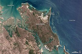
Curtis Island is an island that contains Curtis Island National Park. It is in Queensland, Australia, 474 kilometres northwest of Brisbane and 40 km southeast of Rockhampton.
Contents
Map of Curtis Island QLD 4680, Australia
The island features coastal heaths, littoral rainforest, sand dunes and beach ridges and salt flats. The national park encompasses the Cape Capricorn headland.
No facilities are provided for campers. Bush camping is permitted in three camp grounds.
Southern parts of the island are being heavily developed for multiple coal seam gas export facilities including natural gas liquefaction plants.
Heritage listings
Curtis Island has a number of heritage-listed sites, including:
References
Curtis Island National Park Wikipedia(Text) CC BY-SA