Kalpana Kalpana (Editor)

Cumbria Coastal Way

Updated on
Edit
Like
Comment
Share on FacebookTweet on TwitterShare on LinkedInShare on Reddit
Season
  
All year

Designation
  
National Trails

Length
  
298,000 m

Use
  
Hiking

Cumbria Coastal Way wwwwalkingpagescoukimagesldpcumbriacoastal

Location
  
Northern England, United Kingdom

Trailheads
  
Silverdale, Lancashire, Gretna Green, Dumfries and Galloway

Cumbria coastal way


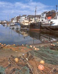
The Cumbria Coastal Way (CCW) is a long-distance footpath allowing users to travel from Cumbria's southern border to just north of the English–Scottish border. It follows some interesting scenery such as the red sandstone cliffs of St. Bees Head.

Contents

This footpath passes through the following locations (from South to North):

  • Silverdale, Lancashire - 54.167°N 2.827°W / 54.167; -2.827
  • Arnside
  • Grange-over-Sands
  • Greenodd
  • Ulverston
  • Barrow-in-Furness
  • Askam-in-Furness
  • Kirkby-in-Furness
  • Broughton-in-Furness
  • Millom
  • Ravenglass
  • Seascale
  • St. Bees
  • St. Bees Head
  • Whitehaven
  • Workington
  • Maryport
  • Allonby
  • Mawbray
  • Beckfoot
  • Silloth
  • Abbeytown
  • Burgh by Sands
  • Carlisle - 54.895°N 2.934°W / 54.895; -2.934
  • Cumbria coastal way


    References

    Cumbria Coastal Way Wikipedia