
Area 1,774 km² | Established November 24, 1939 Phone +52 81 8191 0664 | |
 | ||
Governing body Secretariat of the Environment and Natural Resources Similar DOMINO'S HEB VALLE A, Hotel Hacienda Cola de, Hotel Chipinque, Macropla, Flordeco | ||
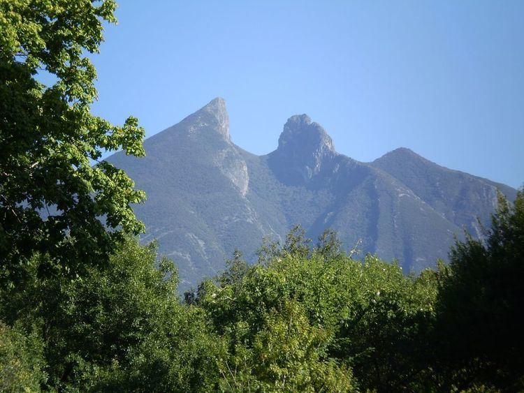
The Cumbres de Monterrey ( ['kumbres de monte'rei] )(English Summits of Monterrey) is a national park of Mexico located in the northern portion of the Sierra Madre Oriental near the city of Monterrey, Nuevo León. The park includes the famous symbol of Monterrey, the signature skyline known as Cerro de la Silla (Saddle Mountain). The park consists of rugged terrain boasting steep mountains reaching an elevation of 2,260 meters (7,410 feet) above sea level, deep canyons, rivers and waterfalls.
Contents
It was created in 1939 under president Lázaro Cárdenas. The park encompasses 177,395.95 hectares (438,354.9 acres); it was created to protect the native flora and fauna against the spreading urbanization of the city of Monterrey. The cool pine-oak forests with winding trails through the mountains make this park a popular escape from the Monterrey metropolis.
History
There are numerous indigenous paintings and stone carvings throughout the park that have proven humans have inhabited the area for thousands of years. Before the Spanish Colonial Period, different groups of Chichimeca inhabited the present area of Cumbres de Monterrey. Many of the different tribes in the region united for years in efforts to avoid Spanish rule. The first European settlement in the area was Monterrey on September 20, 1596.
Cumbres de Monterrey National Park was established on November 24, 1939 by president Lázaro Cárdenas. The park was decreed to encompass 246,500 hectares (609,000 acres) which at the time was the largest area to be declared protected by the Mexican federal government under the regulations of a national park. By decree on November 17, 2000 Cumbres de Monterrey National Park was reduced to an area of 177,395.95 hectares (438,354.9 acres).
Geography
The most accessible portion of Cumbres de Monterrey National Park is Chipinque on the edge of Monterrey about 12 miles from downtown. At the visitor's center, park officials provide information and maps of several hiking paths varying from easy to moderately-difficult. Chipinque is an ecological reserve within the park that allow visitors easy access to many of the flora and fauna found in the park.
The Cumbres de Monterrey National Park is located in the northern portion of the Sierra Madre Oriental was formed by rock folding of marine based sedimentary strata during the Eocene epoch in the Laramide orogeny period. The marine sedimentary rock rose over the years to an elevation of 2,260 m (7,410 ft) above sea level.
The Highest Peaks in the Cumbres del Monterrey National Park
The main sedimentary rock that constitutes the mountains in the park was formed during the Cretaceous. Most of the sedimentary rock has extensive karstification that happened over millions of years creating several underground systems like: subterranean rivers, caves, and aquifers. Grutas de García (García Caves) is one of the largest cave system in Mexico and is one of the most popular attractions within the park. García Caves were hidden for millions of years until being discovered in 1843. Marine fossils have been discovered inside these caves because the lining of the caves mainly consist of oceanic sedimentary rock.
The porous sedimentary rock in the park allows water to filter into subterranean rivers that replenish underground aquifers which provides one of the primary sources of water for the city of Monterrey. Pozo del Gavilán (Eagle's Hole), the only cenote known in northern Mexico is located in the southern tip of the park; it is another prime example of karstification. Pozo del Gavilán is subterraneously connected to Laguna de Labradores (Labradores Lake). Eagle's Hole is a popular site to rappel.
Cañón de la Huasteca the most famous of the many canyons found in Cumbres de Monterrey National Park. The canyon accounts for about 200 hectares of the park. The walls of Cañón de la Huastecan are marked with a significant number prehistoric glyphs created thousands of years ago by the ancient inhabitants of the region. Another popular canyon is Matacanes Canyon where there are several waterfalls of which Cascada de Chipitín (Chipitín Falls) is the most famous.
Throughout the park there are numerous waterfalls, and there may be more to be found because there is an extensive cave system large amounts of water is not drained by surface streams and rivers but subtarrean ones. The two most famous waterfalls are Cascada Cola de Caballo (Horsetail Falls) and Cascada de Chipitín (Chipitín Falls). Easily accessible by a trail, Horsetail Falls is one of the highlights of the park with a spectacular 25 m (82 ft) drop; the water pours over large rounded boulders creating a waterfall that resembles a horse's tail. Chipitín Falls is not easily accessible and requires a difficult hike, some rappelling, and swimming; the waterfall has an impressive 27 m (89 ft) drop. In addition to the many surface streams and rivers there are many ponds and small lakes. The best known lake is Laguna de Labradores.
Climate
The climate throughout the park changes drastically depending on the elevation and the location of the terrain. According to the Köppen climate classification there are several climates within the park. The following climates are listed by elevation in the park.
Elevation 600–1,000 m (2,000–3,300 ft): North tip of the park has a (BWh) desert climate with an average annual temperature of 23 °C (73 °F) and an annual precipitation of 21.7 cm (8.5 in). The southeast corner and central east portion of the park has a (Awh) Tropical Savanna climate with mild winters, summer-autumn monsoon, annual precipitation of 106.4 cm (41.9 in), and an average annual temperature of 21 °C (70 °F).
Elevation 1,000–2,000 m (3,300–6,600 ft): North tip and the southwest corner of the park has a (BSk) Steppe Climate with an average annual temperature 21 °C (70 °F). Central portion of the park has a (Cwa) Humid Subtropical climate with an average annual temperature of 21 °C (70 °F) and an annual precipitation of 62 cm (24 in).
Elevation 2,000–3,000 m (6,600–9,800 ft): Western side of the park has a (Cwb) Oceanic climate with an average annual temperature of 14 °C (57 °F) and an annual precipitation of 68 cm (27 in).
Flora and fauna
The Cumbres de Monterrey National Park has a great variety of ecosystems throughout the park due to the geography of the park where there are many microclimates allowing a greater variety of flora and fauna to flourish. Agave, Dasylirion, and Rhus species are found in many areas of the park. The forest is made up mainly of the following tree species:
The pine and oak forests and steppe are home to many animals. The Cumbres de Monterrey National Park has one of the most diverse ecosystems in the northern part of Mexico. There is a large variety of fish that can be found in the park, but most species are endangered.
The following fish species are present in the park: Astyanax mexicanus, Campostoma anomalum, Cichlasoma cyanoguttatum, Cyprinella lutrensis, Etheostoma grahami, Gambusia affinis, Macrhybopsis aestivalis, Notropis amabilis, Notropis braytoni, Notropis stramineus, Poecilia mexicana, Puntius conchonius, and Xiphophorus couchianus. Even though there are many species of fish, the follow are the only known endemic species: Cyprinella rutila, Dionda melanops and Moxostoma albidum. A significant number of Cyprinodon species still exists but many are endangered and many have gone extinct.
The park hosts a large variety of avian species; the following bird species are the most notable: Accipiter striatus, Aquila chrysaetos, Circus cyaneus, Falco columbarius, Falco mexicanus, Falco peregrinus, Rhynchopsitta terrisi, Speotyto cunicularia, and Spizella wortheni.
The park also has a significant number of mammals, the following are a few of the species found in the park: Puma concolor, Ursus americanus, Canis latrans, and Odocoileus virginianus.